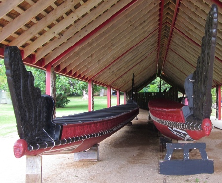
 Two Waka, Ngatoki Matawhaorua on the Right |
Up until that point, New Zealand was in a state of turmoil. Settlers were piling into the country, and there was no controlling authority to police what they did. One of the many outfits that tried to stamp its authority was the New Zealand Company, who were planning to build up their own settlements and create their own laws to govern them. French expansion in the Pacific was also threatening to exert its own authority on the land.
At that point, England didn't really want another colony, but the Crown felt a moral obligation to protect the Maori from unscrupulous land-grabbers. Naval captain William Hobson was instructed to negotiate the transfer of sovereignty over New Zealand to Queen Victoria, and guarantee the Maori full possession and use of their lands. The Treaty of Waitangi began on February 5th, 1840 when a public meeting was held on the grounds in front of James Busby's residence. Lieutenant Governor Hobson read a proposed document to the 300 or so European and Maori who were in attendance and then provided the Maori chiefs an opportunity to speak. Initially, a large number of chiefs spoke against accepting the Crown's proposition to rule over Aotearoa. However, later in the proceedings a few chiefs began to entertain this idea. The proceedings were ended and were to recommence on February 7th; however, a number of chiefs pressed to sign earlier. The Treaty of Waitangi was initially signed on February 6th, 1840 in a marquee erected in the grounds of James Busby's house at Waitangi, by representatives of the British Crown, the chiefs of the Confederation of the United Tribes of New Zealand, and other Maori tribal leaders, and subsequently by other Maori chiefs at other places in New Zealand. Not all of the chiefs chose to sign this document, with a number of chiefs either delaying or refusing to put pen to paper.
However, all was not well. Two treaties had been drawn up; the English Treaty giving Queen Victoria "governship", and a Maori "translation" which translated as "giving the Maori unqualified exercise of their chieftainship" over their lands. The debate carries on to this day as to whether the British and Maori signed the same deal.
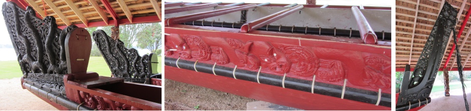 Details of Ngatoki Matawhaorua |
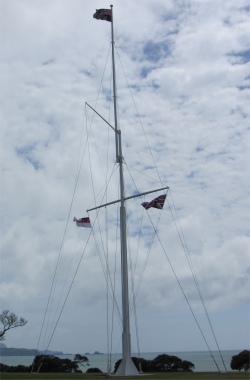 Waitangi Flagstaff |
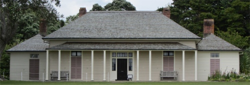 The Treaty House |
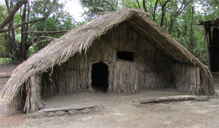
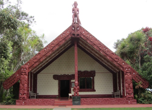 Te Whare Runanga - the Meeting House, with Explorer Kupe at the Apex |
The walkway took us down to Hobson's Beach where the waka house shelters the world's largest war canoe (waka). The 35m-long Ngatoki Matawhaorua, was named after the vessel navigated by Kupe when he discovered Aotearoa, and built from two huge kauri. It is traditionally launched each Waitangi Day, propelled by eighty warriors. The woman explained that you need at least eighty just to get the craft moving in safety. It had intricate carvings down its side, with shells inlaid for eyes. These were to represent the ancestors of the warriors. My mind boggled at how the craft had been shaped using simple stone adzes, taking into account the timber was the extremely dense and hard kauri.
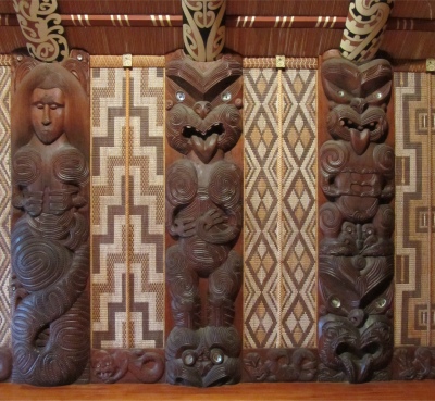 Te Whare Runanga Carvings Representing Different Tribes and Tukutuku |
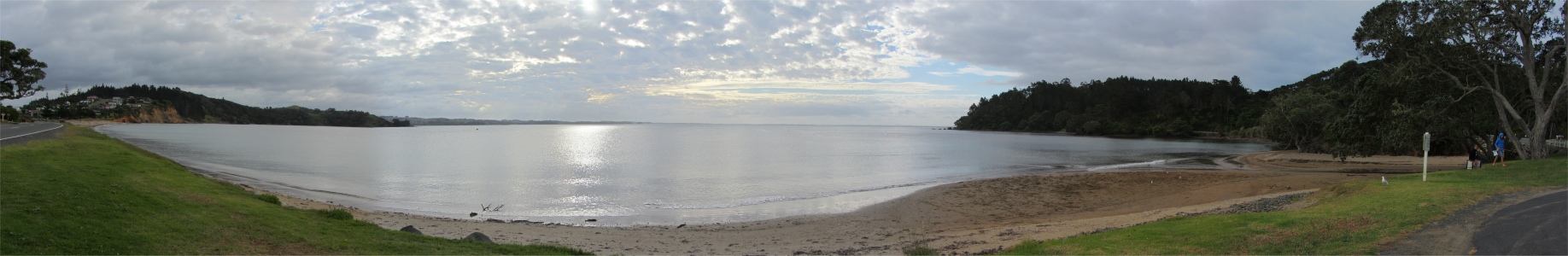
At the level plain, a naval flagstaff indicated the approximate position of where the Treaty was signed. The New Zealand flag fluttered at the top in the steady breeze. At the yardarm, two flags flew, one the Union Jack, the other was a flag designed by Busby in the pre-Treaty days, and often called the New Zealand flag. It was issued then to recognised ships that did trade in those waters.
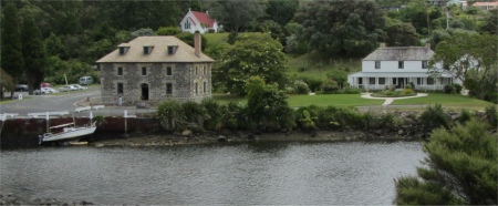
A short walk from the flagstaff across manicured lawns took us to the major focus of the reserve, the Treaty House, a beautifully restored Georgian colonial style building, built between 1833-34, and once the home of James Busby. Most of the Residency was pre-cut in Sydney of Australian hardwood, then shipped to the Bay of Islands and assembled on site. Busby had sailed to Australia when he was 22 years old, and was then posted to New Zealand seven years later with the job of sorting out the lawlessness in the land; not an enviable task I'm sure. Incidentally, he had successfully cultivated grapes in Australia, and he spearheaded vineyards in New Zealand.
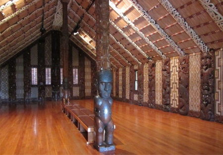 Interior of Te Whare Runanga |
My tour had come to an end now, so I thanked her, we made our farewells, and I moved on to my next appointment, the Maori Cultural Performance. Here a Maori woman in full costume greeted me, a German couple who had recently immigrated, and an English family. She sounded almost cockney the way she called us all lovelies. We were led into a small theatre, where two Maori men and a couple of Maori women performed a series of distinctive song and dance routines of northern Maori tribes. They incorporated a guitar which rather spoilt it for me; it didn't seem authentic with that instrument. And then, as usual, I was dragged down to the stage, but fortunately so were the other men, and we were given rudimentary instructions on how to perform the haka. Then we proceeded with the two Maori guys to go right through the haka, knocking lumps out of ourselves and trying to look ugly and frightening, not difficult in my case. It had all been good fun, and some of the Maori songs were quite moving, even though I had no clue about what was being sung.
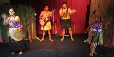 Maori Performers |
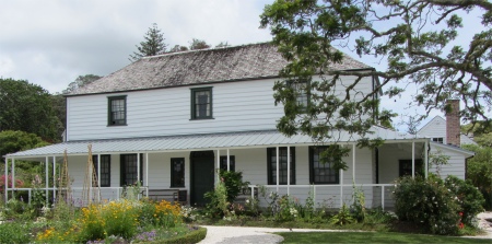
The Kerikeri River wound its way up to the tidal limit at Kerikeri Basin, an area rich in historical importance. Here the country's oldest surviving wooden building was established in 1822, the two-storey Mission House. The Reverend John Butler had it built on land traded by the local Maori chief, Hongi Hika, for a batch of axes. It became the residence of lay missionary and blacksmith, James Kemp, in 1832. The Kemp family vacated the building in 1974, after which some restoration work was carried out on the property.
 Kerikeri Basin |
 Kemp's House |
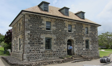 Stone Store |
 Rewa's Village Chief's House |
The bay is also known for being the final resting place of the Greenpeace flagship, Rainbow Warrior. During the 1960s, the French government had ignored the 1963 Partial Test Ban Treaty, outlawing atmospheric testing of nuclear devices, and continued to conduct tests on Pacific atolls. Despite their reassurances that no radioactive fallout would reach inhabited islands, radiation was detected as far away as New Zealand. Rainbow Warrior was nominated in 1985, to lead a Greenpeace protest flotilla from Auckland to the French nuclear test grounds. On 10th July 1985, French secret service agents bombed Rainbow Warrior to prevent the protest, resulting in a Greenpeace photographer being killed. The French government were eventually forced to admit to international state-backed terrorism, but managed to negotiate for the two agents to serve their ten year sentences on a French Pacific island. There they served less than two years before being honoured and returned to France. The bay's local Maori tribe offered the ship its final resting place in these waters, the same graveyard where their ancestral waka, Matoatua, lies. It has become a living reef, attracting marine life and recreational divers. It seemed a fitting end for a ship that had spent its time protecting the marine environment.
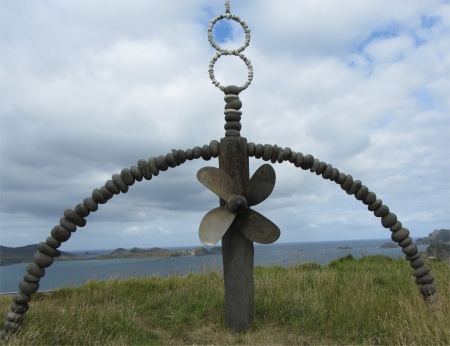 Rainbow Warrior Memorial |
I dismounted the hill, and returned to the cafe to grab a coffee before my final leg of today's journey. Inside were two voices appearing out of the depths, both intently poring over two ledgers, trying to get the two tomes in sync with each other by the looks of it. There was a lot of rubbing out and pencilling going on. While they were engrossed in the current quick fix, I noted from the row of certificates above the counter that these were Mrs Grimwood and Mrs McKinley. When they had time to come up to breathe, I asked if I could buy a coffee. The usual response came, "What type of coffee?" "Hot, wet and white," I replied. Then she rattled off all the designer coffees that you get across the globe now. "When I was young, coffee was coffee," I said. "You want flat white," was the response to that, and she went off to make it. Meanwhile Mrs Grimwood carried on with the books, talking very loudly to herself. "You talking to me?" I asked, hoping she would take it as a joke. "I always talk to myself when I do the books. It is the only way I can concentrate." "You know, if you did all this using a spreadsheet on your laptop, it would be a lot simpler," I declared. "No it wouldn't, I like to see everything on a big page in front of me, I can read it better," was her considered response. "But if you ....," she cut me off there. "I don't like laptops," she snapped, and resumed talking to herself and rubbing out columns. Mrs McKinley returned with my coffee, and instantly launched into a heated debate with Mrs Grimwood, who had just erased a complete column of important information. Hmmm ... I thought, there is no undo button on your written ledger. I thanked them for the coffee, and left them to rewrite the books.