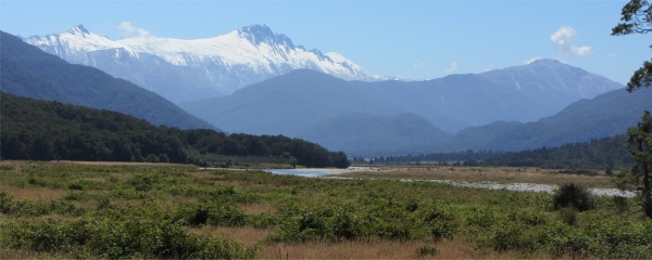
Mount Hooker from Haast Pass
|
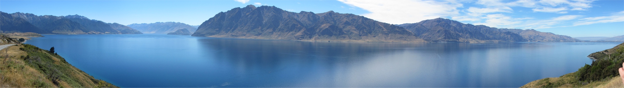
I headed northeast under blue skies out of Wanaka, and having reached Hawea, followed the western shore of the eponymous lake, crossed the isthmus called the Neck, and re-joined the upper shores of Lake Wanaka. From there it was a long climb from Lake Hawea through beech forest, then cold wet bush climbing sheer on either side of the road. Lacy waterfalls tumbled down from invisible heights. I was now crossing Mount Aspiring National Park, the nation's third largest. The names associated with the area spoke volumes about its terrain: Mount Awful, Mount Dreadful, Mount Chaos, The Valley of Darkness, Solitude Creek and Siberia River are just a few. The apex of this route was 563m Haast Pass, the most southerly crossing to the west coast. From this point on streams would flow into a different ocean.
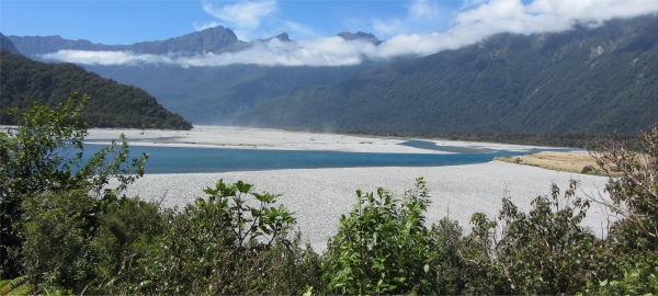
Haast River Winding its Way Down to the Tasman Sea
|
Maori had used this route when crossing the alps in their search of greenstone. Prospector Charles Cameron was the first Pakeha to cross in 1863. A few weeks later the German geologist Sir Johann Franz Julius von Haast crossed, and took it upon himself to name the pass. The pass became open to vehicles in 1965, and it was finally completely asphalted in 1995. Tussock and scrub ruled here, plagued by landslips and floods. From here it was all downhill to the rain-soaked forests of the West Coast. And it was here that waters gathered for the long churn and tumble down to the Haast River and finally the Tasman Sea, cascading through the Fantail Falls, Thunder Creek Falls and Roaring Billy on the way.
On the lower plains I had to stop a couple of times while herds of cows were driven up the highway by farmers on horseback; this really is the wild west.
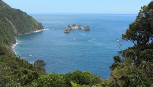
Knight's Point
|
I entered the splintered hamlet of Haast, crossed the 750m Haast River Bridge, the longest single-lane bridge in the country, and headed off in a northerly direction. Before me lay the notorious West Coast, an untamed strip of land 400km long and roughly 30km wide. On my left were the moody, surf-pounded beaches on the Tasman Sea. To my right lay the backbone of the South Island, the Southern Alps, with countless rivers tumbling down the slopes to get their second breaths in lakes, forests, swamps, bush, sand dunes and meadows before joining the pummelling waters of the Tasman Sea. This was a tropically wet domain, the copious amounts of rain having a detrimental effect on the soil, reducing it to peat-like composition. The alternating downpours and sunshine were ideal conditions for marijuana, an undeclared component of the local economy.
This coast was peopled by a special breed, the "Coasters". They stemmed from early gold and coal miners, and were an independent clan who prided themselves on their ability to coexist with the raw nature of this remote strip. In some ways they reminded me of the mining immigrants who settled
Butte, Montana; a town which seemed to keep itself separate from the rest of the state.
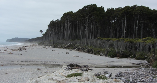
Rainforest Meets the Tasman Sea
|
In times gone by, rocky headlands, storm-swept beaches, fearsome rivers and impenetrable coastal forest caused early travellers to bypass this area or take to the sea. Shipping was the lifeline of the pioneer European settlers of Haast and Jackson Bay. Supplies were rowed ashore to sandy beaches and cattle forced to swim.
Explorer, Charles Douglas, wrote:
"
It used to be a study watching a long line of loaded pack horses with perhaps only one man driving. Going around a bluff in heavy weather, the loads were usually from 250 to 300 pounds of a very mixed character. The horses ..... could watch the sea far better than most men ..... the animals would all stop and watch the sea coming in, then make a run for it. If by chance they got caught, they had a way of propping themselves face or back to the waves, and holding their own, then as the sea receded off they went at a trot."
The main supply centre was at Okarito, the third largest port on the West Coast in the 1860s. The beach became the main highway for people and supplies moving along the sliver of coast. Travellers on foot, with packhorses and with horse and cart, ventured with determination between the isolated gold towns to the north and south. Quick sands and wild surf often caught the unwary. Drownings at river mouths were common, as were dire weather conditions. This was no territory for the fainthearted.
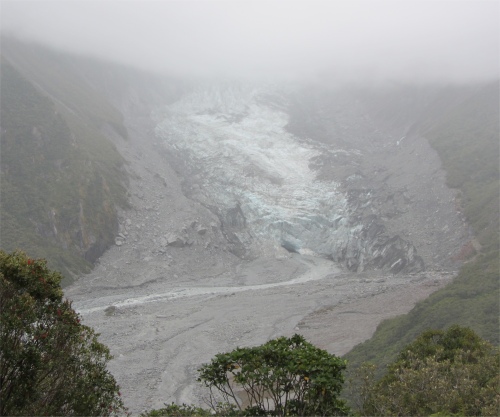
Fox Glacier from Chalet Lookout
|
"
Death by natural causes or "Visitation of God" accounted for barely 14%. Of the remainder, 47% were drowning, 20% mining accidents, 12% cause uncertain."
While cattle came to the district by sea, they went out to northern saleyards via an inland route, known to early travellers as Maori Saddle. The route is now the Historic Paringa - Haast Cattle Track, and is used for tramping.
It wasn't until the 1930s that isolated South Westlanders experienced more regular contact with the outside world. Using beaches and paddocks as airstrips, Captain Bert Mercer's Air Travel (NZ) Ltd provided mail, goods and passenger services.
A road was finally opened over Haast Pass in 1960, linking Otago with Jackson Bay, but the Haast to Paringa stretch linking Otago with Westland was not completed until 1965. Work gangs started at both ends. The last 10km, near Knight's Point, took more than two years to build.
My route took me along a long, long, slightly undulating strip of asphalt hemmed in by walls of dripping, impenetrable greenery. The road left the tea-coloured coast at Knight's Point and soon I found myself entering the Westland Tai Poutini National Park, which butted up to Aoraki Mount Cook National Park. Indeed I was probably less than 30km away from Mount Cook Village where I based myself around three weeks earlier, but the jagged peaks of the Southern Alps, with their permanent snowfields, formed an impenetrable barrier. Legend has it that the beautiful Hinehukatere loved the mountains so much that she persuaded her lover, Tawe, to climb alongside her. He fell to his death and Hinehukatere cried so profusely that her tears froze and formed two glaciers, Ka Riomata o Hinehukatere - "The Tears of the Avalanche Girl". The predominant highlights of this national park were two glaciers. Initially named "Albert" and "Victoria", they were later renamed. In 1865, Julius von Haast named one after the Austro-Hungarian emperor, Franz Josef. In 1872, the other was renamed after a visit by visiting Prime Minister, William Fox.
At long last I arrived into Fox Glacier, a small village with a cluster of small cafes, restaurants, souvenir shops, an assortment of accommodation options, and an abundance of activity companies. I wanted to tackle a walk on a glacier, and guide companies exist to provide that service. "What's the weather forecast for tomorrow?" I asked the young woman behind the desk. "It is meant to start with drizzle, followed by rain around noon," she replied. Hmmm.. shan't book for tomorrow I thought. I decided there and then to opt for trying a walk on the Franz Josef Glacier the day after tomorrow.
To keep myself amused and stretch my legs, I drove alongside the Fox River as far as I could, and then proceeded to walk up the Chalet Lookout track through dense rainforest.
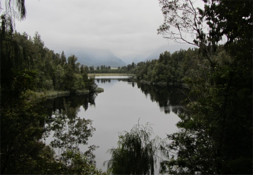
Cloud Covered Southern Alps from Lake Matheson
|
On my way I crossed paths with an English couple, about the same age as me. They were spending 5.5 weeks in New Zealand as part of their round-the-world trip. They had just come from China where they were staggered by the temperatures. In Beijing, it was -15�C. The chap had been on a bus, and showed the conductor he had prepared himself by donning a set of thermals. The conductor pulled him down a peg or two by telling the chap he needed more layers, and promptly showed the chap his nine pairs of thermals that he was wearing. I presume trips to the Great Wall were reserved for those wanting that extra special cryogenic treatment. Their next port of call would be the Cook Islands, followed by San Francisco.
I continued my hike and reached a wooden viewing platform. This was close to a chalet hut where early glacier guides used to brew a cuppa for their clients in the 1930s. Opposite me was the lowest stretch of the mighty Fox Glacier, hemmed in by its lateral moraine and dense rainforest. The Fox River gushed out from an ice cave at its base. Sadly the vast upper reaches were shrouded in low cloud.
At 13kms, Fox Glacier is the longest of the awe-inspiring New Zealand West Coast glaciers. At its head, soaring peaks of over 3000m dominate the vista, where annual snow precipitation of 5m was typical. These included Aoraki (Mount Cook) and Mount Tasman. This mighty moving river of ice falls 2600m on its journey from the base of the Southern Alps to the West Coast. The western slopes to the alps were particularly steep, producing some of the fastest moving glaciers on the planet. Indeed the Franz Josef glacier advanced on average at a speed of 1m per day, but had been known to reach the dizzy speed of 5m per day.
For these latitudes, New Zealand's West Coast glaciers are unique and probably the most accessible glaciers in the world, as they terminate amongst temperate rainforest just 250m above sea level. The juxtaposition of ice and vegetation provided a unique ecosystem. So special is this mountain environment, that it forms part of the South Westland World Heritage Area.
After I had had my fill of this majestic vista, I headed to Lake Matheson, a "must see" attraction. It was formed when the glacier retreated 10,000 years ago at the end of the last ice age. Early morning was the best time to capture the snow-capped summits of Mounts Cook and Tasman, perfectly mirrored in the placid waters. Sadly, today a breeze ruffled the lake, and spoiled the mirror image of cloud on alps.
I fairly flew around the lake, and having done three hours of brisk hiking with ease after my long car journey, I smiled as I realised that I was now getting fitter, just as well really if I wanted to do a 9 hour hike across a glacier.