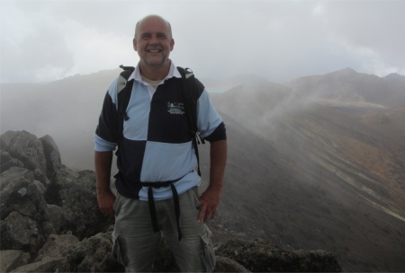
The Intrepid Explorer on Mount Tongariro Summit 1967m
|
I walked a couple of hundred metres down the road and looked across at the mountains. Visibility was good over the plain, and a few clouds were scudding across it casting large moving shadows. The bases of the great mountains were clear, but their summits were capped with cloud. I walked back to the chap and gave him my report. He in turn advised that the latest forecasts suggested that today was the most promising day, the weather would take a turn for the worst the following day. I made an instant decision to go for it.
"Put me down for the 8am bus please, and can you also please advise the camp reception when they open that I have left my car on site and will require another night," I asked the man. "Good as gold, I'll sort it, and just square up when you get back," he replied.
I quickly packed my backpack. It was cool so two bottles of water would suffice - why carry extra weight? For food, a few biscuits and a couple of apples would be more than enough. Fleece and waterproof jacket, and I was ready. I snatched an apple, and ate it quickly, that was breakfast.
Sixteen of us piled on the bus. The driver gave us a repeat of the weather forecast, and stressed the average timings for the crossing, plus extra time needed to be taken into account for deviations such as climbing up to the summits of Mount Ngauruhoe or Mount Tongariro. The return busses from the far end of the crossing would be 3, 4 and 5pm. All people would be counted out and counted in as a safety measure, and folk missing the last bus would have to pay extra. Hazards were highlighted, the main one being Mount Ngauruhoe. Its slopes were covered in scoria and loose rocks, many of them large. These can be dislodged by hikers, resulting in avalanches of deadly missiles hurtling down the slopes. This year several people have suffered broken legs and serious head injuries. The mere mention of scoria put me off Mount Ngauruhoe straight away. We were all issued with an emergency number to contact if we had problems, and we all left details of where we were staying and our mobile numbers.
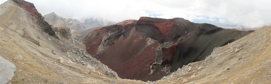
Red Crater
|
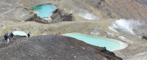
Emerald Lakes
|
With all the formalities out of the way, we had a 20 minute drive to the car park on Mangatepopo Road, alighted, and set off at our own pace. I was aware of the weather turning foul later, so I pushed myself pretty hard.
The hordes of like-minded hikers was a strong indication that this was not going to be a solitary hike, and on reaching the trailhead, a long line of multi-coloured jackets in the distance betrayed the human activity. The first hour was taken up following the Mangatepopo Stream through barren lands, and past the Mangatepopo Hut. I started to gain height as I scaled twisted, fractured, black lava flows, which curiously reminded me of Edvard Munch's The Scream.
Walking straight past the Soda Springs point on the track, I continued the climb up to the Mangatepopo Saddle, which hung between the bulky ancient Mount Tongariro and the sprightly Mount Ngauruhoe. The climb was up what was referred to as the Devil's Staircase. It was a lung busting, heart thumping slog creating the odd gallon of lactic acid in my legs. Banter and camaraderie was built up as I passed other suffering souls.
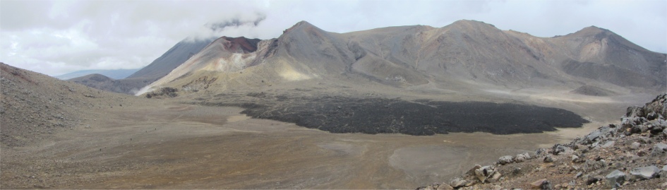
Central Crater with the Black Lava Flow at the Bottom, Behind Red Crater Stands Mount Ngauruhoe Partially Obscured by Cloud
|
There was a fair old party going when I reached the top of the saddle. Folk were strewn out in various comatose poses, ravenously eating food to replace all the calories they had burnt off during the climb. I joined the happy throng and ate a biscuit and took a few swigs of water.
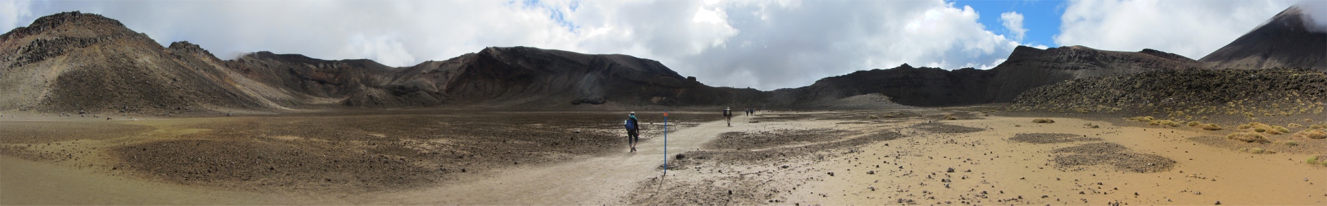
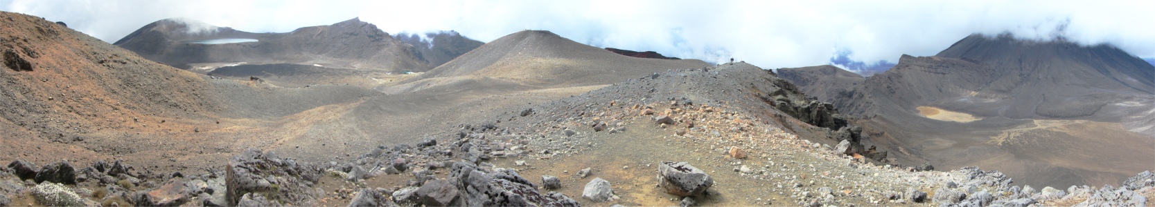
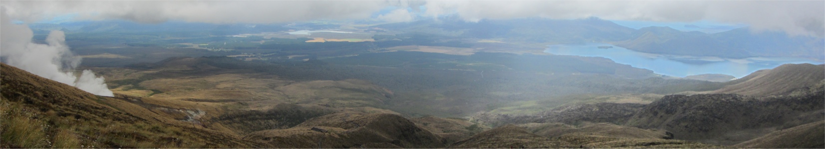
I took in the wondrous panorama below me, across the route I had taken up the Mangatepopo Valley, with the plains and mountains beyond. The earth was dappled with sunlight as clouds scudded on their way towards the mountains I was now on. I didn't linger long and soon headed from the saddle across the flat pan floor of the South Crater.
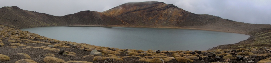
Blue Lake
|
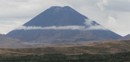
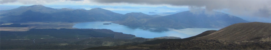
After a strenuous climb out of the South Crater, I came across another throng of people munching away at a natural stopping point. Here I took the once in a lifetime opportunity and followed a poled detour up to the summit of Mount Tongariro. On the way I passed amazing grotesque lava outcrops, and I was also afforded views of the Blue Lake and Emerald Lakes. Again camaraderie was established on this short 1.5km hike to the summit. A pair of lads, one Dutch one German, arrived at the same time as me, and we did the obligatory swapping of cameras to catch that special moment on top of this 1967m peak. By now, the vista to the west was just a mass of grey, but views were still to be had looking east. To the southeast lay the expanse of the Rangipo Desert with its shifting black sands. 155km way over to the west was the volcano Mount Taranaki, where I had visited last December. Sadly the cloud cover blocked it from view.
The three of us headed back from the summit together, but the two lads fancied taking a shortcut across to the lakes. "Do you think it is shorter to go straight across?" they asked. "Yeah, it is shorter but probably slower. Your best bet is to stick to the marked track," I answered. But youth is always headstrong and they tried to go straight across a valley.
I returned to the main alpine crossing again, and climbed up to the rim of the Red Crater. Crimson and black bands lined the crater walls like strata. I was bowled over by the sight of this geological sight, and I could not comprehend the power that created it.
I began the long descent from the highest point of the crossing, 1886m, down to the Emerald Lakes, serene, opaque pools with vibrant shades running from jade to duck-egg. A whiff of hydrogen sulphide lingered in the air emanating from the steam belching out of fumaroles and hot springs near the lakes. I heard a shout and saw the two lads, who I had met on Tongariro summit, climbing up a rise towards the lakes. "I told you it would be faster to follow the designated route," I teased them. They let it go. "You missed out on the red crater, it is quite something," I told them, pointing back up the hill from which I had just descended. After a hurried tete-a-tete they decided to climb the hill to see the crater. "5 minutes should do it," said one. "Make it 10 minutes," I quipped in. They smiled, and off they climbed.