Archeological evidence showed that people had lived in these canyons for nearly 5,000 years, longer than anyone had lived uninterrupted on the Colorado Plateau. The first residents built no permanent homes, but remains of their campsites and images etched or painted on canyon walls told us their stories. Later, people called Basketmakers built household compounds, storage facilities, and social and ceremonial complexes high on ledges on the canyon walls. They lived in small groups, hunted game, grew corn and beans, and created paintings on the walls that surrounded them. Ancestral Puebloan people followed. Predecessors of today's Pueblo and Hopi Indians, they are often called Anasazi: a Navajo word meaning ancient ones. These Puebloan people built the multi-storied villages, small household compounds, and kivas with decorated walls that dotted the canyon alcoves and talus slopes.
About 700 years ago most people moved away (striking similarity here with Mesa Verde and Hovenweep), but a few remained in the canyons. Later migrating Hopi Indians and other tribes spent summers here, hunting and farming. When bands of Navajo first arrived in the Southwest, the Anasazi pueblos in Canyon de Chelly were deserted ruins. By 1600, the Navajo had become nomadic farmers. A century later they were known for their sheep, blankets of finely woven wool, and fields of corn.
The name Navajo was a Tewa-Pueblo Indian word meaning "Great Planted Fields". Dine'e, The People, was what the Navajo called themselves. Canyon de Chelly provided the Dine'e with two important necessities: a suitable location to raise crops and herd sheep, and protection from their enemies.
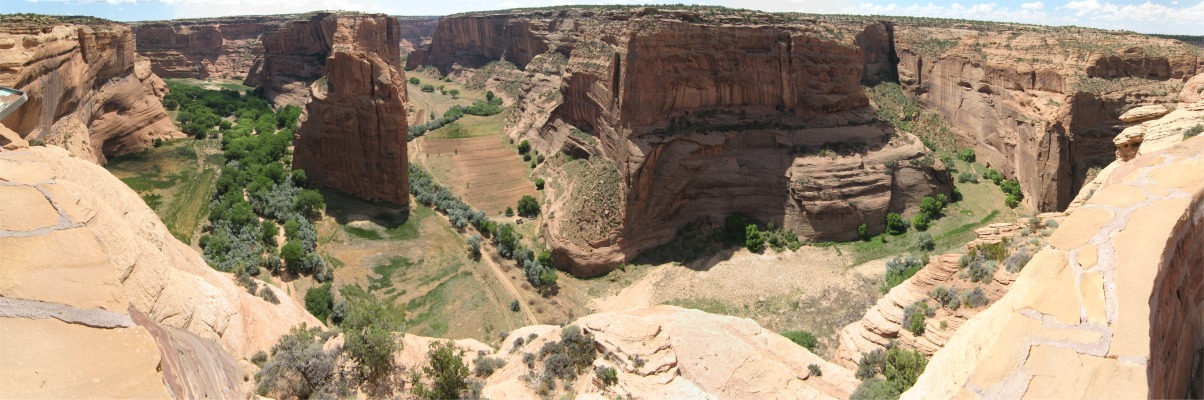
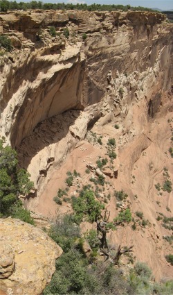
The labyrinth called Canyon de Chelly (d'SHAY) was really several canyons that included Canyon de Chelly and Canyon del Muerto. At the canyons' mouth near Chinle, the rock walls are only 30' high. Deeper in the canyons the walls rose dramatically until they stood over 1,000' above the floor. Cliffs rose straight up, overshadowing streams, cottonwoods, and small farms below. It had taken millions of years and volumes of water to etch those stone paths through the layers of sandstone and igneous rock as the Defiance Plateau rose. The canyon beckoned me today, with its towering stone monoliths and ledges bearing the open windows of ancient people.
 Navajo Fortress |
I decided to tackle the North Rim Drive first, with my first stopping off point being Antelope House Overlook which also afforded a splendid view across to the Navajo Fortress. By 1750, the Navajo was farmer and herdsman. Yet he remained a warrior, fighting his Indian enemies as well as the encroaching Spanish settlements. Raids and counter-raids dragged on for more than 100 years. The huge rock formation marking the junction of Del Muerto and Black Rock Canyons was one of the refuges used by the Navajo against enemy attack. "Stairways" of movable, notched poles were positioned to reach otherwise inaccessible areas. Use of this refuge continued into the 1860s.
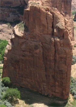
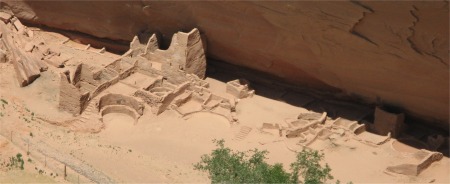 Antelope House |
Building at Antelope House began around AD700 and continued on and off for nearly 100 years. Most of the structures visible at Antelope House were constructed after 1050. The Navajo called this site Jadi Dayijeehi, Running Antelope, because of the paintings of the antelope on the cliff face just to the left of the ruins. These elegant paintings were believed to be the work of the Navajo artist Dibe Yazhi, Little Sheep, who lived in the canyon in the 1830s.
Sharing the same wall were Anasazi pictographs, painted hundreds of years before the Navajo came to Canyon de Chelly. Found throughout the canyon, these fascinating art forms, simple, sprightly, and ofttimes humorous, seem to tell us a great deal about the people who created them.
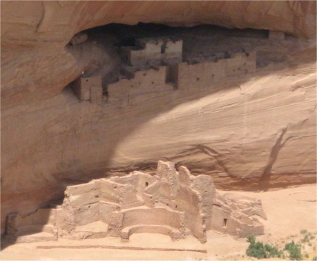
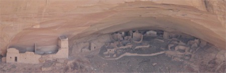 Mummy Cave |
The large rooms and masonry of the central tower were Mesa Verde in style and contrasted with the coarser construction in the smaller rooms at either side. This dramatic evidence suggested that people from the Mesa Verde area may have moved into Canyon de Chelly sometime around 1280.
Before moving on to the next overlook, I stopped for a chat with a Navajo chap who was selling jewelry and trinkets. I learned that the Navajo worked in partnership with the national parks, the latter look after the buildings and artifacts in the canyon, while the Navajo had the freedom to grow crops and rear livestock. As well as traditional corn, beans and squash, the farmers grew melons and cultivated fruit trees. During the summer, the canyon floor was about 10 degrees F warmer than the mesa, but in winter it was a lot colder than the mesa; the streams would turn to ice (I thought the floor would be warmer). Any excess food would be stored for the winter and the animals would be brought up to the mesa and hay bought in. The fellow's family still farmed down in the canyon, but he lived in a community on the mesa not far from the rim, and eked out a living selling his wares; there was no other work for him.
 Massacre Cave (rocky ledge in shadow) |
Spanish accounts described a day-long battle against Indians "....entrenched in an almost inaccessible point ...." and the killing of 90 warriors and 25 women and children. The Navajo, however, said many men were away hunting at the time. Thus the dead were mostly women, children and old men who had sought refuge from the invaders (reminded me of Big Hole National Battlefield).
The Navajo called the alcove Adah Aho'doo'nili, Two Fell Off, referring to a brave Navajo woman who grappled with a soldier and tumbled to her death, dragging the enemy with her.
 Yucca and Mummy Cave Ruins from Massacre Cave Overlook |
 Tsegi Overlook |
These farms produced crops for individual families, with little left over for sales. And even this marginal production was threatened by late spring and early fall frosts, sandstorms, summer droughts or torrential rainstorms.
The Navajo blokes trying to sell their wares on the south rim were a little pushy. There was one young lad who was trying to get me to use his uncle as a Navajo guide for the canyon. I got the spiel about follow the big hill out of town, take a left, then second right blah blah. No, I wasn't interested. What really annoyed me about this little squirt was that at the end of every other sentence he had to spit. What was he trying to prove? At another overlook an older guy sidled up and said he could tell me only the stories the Navajo knew. Once I got a whiff of him I knew it would be only drink that was talking. Even though they were trying to survive, I was quite firm with them in saying thanks but no thanks.
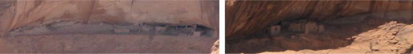 First Ruin and Junction Ruin from Junction Overlook |
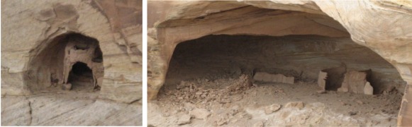
Shallow, dry alcoves seen on the far side of the canyon wall provided sheltered building sites for the Anasazi. Their first dwellings were pithouses. Later they built many-roomed structures of stone and mortar.
Ruins of two Anasazi villages built more than 700 years ago were visible from the overlook, First Ruin to the left, and Junction Ruin to the right (named by the first archeological expedition into the canyon).
 White House Ruin |
At its zenith, the village housed 100 men, women and children in some 60 rooms constructed of stone blocks with mud mortar.
I swiftly moved on to Sliding House Overlook. The Navajo knew this prehistoric Anasazi village as Kindazhoozhi, which meant Sliding House. It was an apt description. The dwellings were constructed upon a steeply sloping edge, and even the ingenious Anasazi builders were unable to keep many of the walls from slipping. Evidence suggested that at one time this was a very large village of from 30-50 rooms. Occupation of the site probably began around AD900 and continued for about 300 years.
Face Rock Overlook had four groups of buildings hidden in alcoves on the opposite cliff face. The final stop off was Spider Rock Overlook. Spider Rock was an 800' sandstone spire that rose from the canyon floor at the junction of Canyon de Chelly and Monument Canyon. On a board overlooking the rock the following words were written in both Navajo and English:
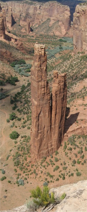 Spider Rock |
Navajo Night Chant
Listen.
Smell the pungent juniper.
Ancient Black Rock hunches on the distant horizon.
A dark cloud above means rain will soon be upon us.
The awesome monolith at you feet is the Tse Na'ashjee'ii, Spider Rock. Holy Spider Woman is an important deity, in Navajo mythology. It was she who taught the People how to weave.
There is purity and strength here. And places sacred to the People.
Places strong in the oneness of earth and sky and of all things.
"I am indeed the child.
Absolutely I am earth's child"
Navajo Song of the Earth
I met a German couple at the Spider Rock Overlook, and their English was impeccable. I have a lot of admiration for anyone who can master another language. Their German wasn't too bad either; they were from Munich where Bavarian is normally spoken, which a lot of Germans can't even follow.
After my tour of the rims, I felt the overwhelming desire to have a shower, so I headed straight to the sports centre. The centre was just off the main highway, and as I approached it I was both amazed and amused to see some healthy looking cows strolling down the highway without a care in the world, similar to the bison in Yellowstone Park. Nobody around seemed to bat an eyelid. There was a different girl on the sports centre reception desk today. I again asked to buy a shower, and it was no problem, just $1. Then, as appears to be the custom in the US, she asked me for how many. I looked around and saw there was only one of me. "Just for me, unless you want to join me", I jokingly replied. Fortunately she saw the funny side and laughed. One of these days I'll get a clout. I asked her if the Navajo Indians had some alliance with India in allowing cows to wander around the streets. She giggled and said the farmers were sometimes careless.
From the shower I went straight to the one and only shopping centre to make use of the launderette This really rammed it home to me that I was on a Navajo reservation. It was pretty packed with Navajo, presumably most Indians don't have washing machines. Despite that they didn't object to this foreigner with a lighter shade of brown intruding. I was a bit annoyed with myself, I must have set the wrong temperature on the dryer and three of my T-shirts came out scorched.
Having completed my laundering, I looked over the shopping centre. 80% of the buildings were empty, but nothing was derelict. The centre seemed fairly new; single story with adobe red colours for the brickwork. I spotted a pizza place, and not having had a square meal for 24 hours apart from porridge, I did not resist the temptation. Again, I was the only non-Navajo. The character who served me, well I had a job to tell whether he was extremely camp or transsexual; imagine that of a character with standard Navajo high cheek bones, dark skin and, well pretty peculiar hairstyle. The musak in the background was Navajo chanting.
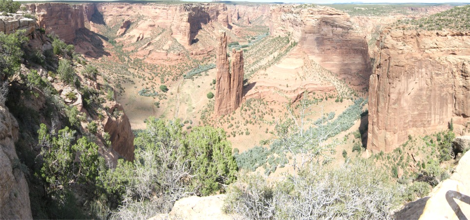 Panorama of Spider Rock |
Driving back through Chinle, It seemed a modern but run down town. There were more than enough agencies for benefits, child correction centres, lots of cheap housing, and an abnormally number of what I'd call cult religious buildings. Apart from service industries, there was very little evidence of industry. It seemed to me very sad that here was a race, who originally had a lot of soul, and have now resorted to living in a place that appeared to me as if it had no soul. Maybe I was missing something, but it just seemed like a town sized motel in some ways; folk staying here till they move on to their next world. Yet down the road was a spectacular canyon where they once had a lot of soul. There was something missing, but I couldn't put my finger on it. The heat and driving had taken its toll, and I just wanted sleep.