 Ships on the Waddenzee |
The Waddenzee (Wadden Sea) landscape has been formed for a great part by storm tides in the 10th to 14th centuries, overflowing and carrying away former peat land behind the coastal dunes. The present islands are a remnant of the former coastal dunes. It is the largest unbroken system of intertidal sand and mud flats in the world. The site covers the Dutch Wadden Sea Conservation Area, the German Wadden Sea National Parks of Lower Saxony and Schleswig-Holstein, and most of the Danish Wadden Sea maritime conservation area. It is a large, temperate, relatively flat coastal wetland environment, formed by the intricate interactions between physical and biological factors that have given rise to a multitude of transitional habitats with tidal channels, sandy shoals, sea-grass meadows, mussel beds, sandbars, mudflats, salt marshes, estuaries, beaches and dunes. The area is home to numerous plant and animal species, including marine mammals such as the harbour seal, grey seal and harbour porpoise. Wadden Sea is one of the last remaining large-scale, intertidal ecosystems where natural processes continue to function largely undisturbed.
Towards the North Sea the islands are marked by dunes and wide sandy beaches, and towards the Wadden Sea a low, tidal coast. The region is continually contested by land and sea. The impact of waves and currents carrying away sediments is slowly changing both land masses and coastlines. For example, the islands of Vlieland and Ameland have moved eastwards through the centuries, having lost land on one side and added it on the other.
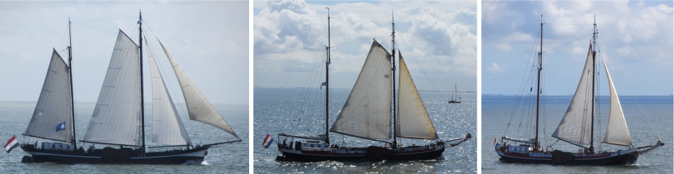
Despite all the activity, an air of tranquillity presided over this vast watery plain. The sea was quite calm, with vessels silently appearing over the horizon. Harlingen slowly sank beneath its eastern horizon, and the islands of Vlieland and Terschelling slowly rose up from the sea to the west.
A family plus dog sat next to us on the top, outside deck of the ferry. After a short while, the man turned to me and asked, "You speak English?" "Yes, I am English," I replied, and we fell into conversation.
He had a slight lilt to his voice, and he explained he grew up in Wexford in Ireland.; his father was Irish and his mother African. I learned he had set off 30 years ago to do a job in Germany, stopped over in Holland on the way, met his wife who was from Friesland, and decided to stay. They now live in Breda, two of their daughters are nurses and the third is a student.
He had trained as a mechanical engineer, and had migrated to being a builder. He owned his own company employing fifteen staff; a Scotsman, a few Poles plus others. The company refurbished "Heeren" houses, substantial houses for the "landed gentry."
He and his wife were keen hikers, often walking over 20 miles, plus they swam every day. "Crumbs, if you cycled every day you could start doing triathlons," I joked. "My wife does," he replied. The family were renting a house on the island for a few days, just chilling out.
I also learned he has a sister who has taken in his 93 year old mother to care for. Bizarrely it turned out his sister lives in Rushmere Road, at the bottom of the road I live in.
 Approaching Terschelling |
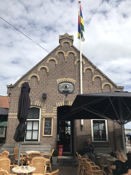 't Wakend Oog |
The island was formed in the Middle Ages from a sandy area called De Schelling in the west and the original island Wexalia in the east. The name Wexalia, Wuxalia, or Wecsile is the medieval name of eastern Terschelling. However, this name disappeared at the end of the Middle Ages. The last appearance of the name Wexalia is in a treaty between Folkerus Reijner Popma, then ruler of Terschelling, with King Edward IV of England in 1482.
The oldest traces of civilisation on Terschelling date from around 850, when a small wooden church was built on a hill near Seerip or Strip. This hill was later used as a burial ground and is known as the "Striperkerkhof".
The Dutch navigator Willem Barentsz was born on Terschelling around 1550. Historically, tensions existed between the inhabitants of West-Terschelling, with its strong orientation towards the sea, and the more agriculturally oriented inhabitants of East-Terschelling. In 1612 this led to the division of the island into independent political entities, West-Terschelling and East-Terschelling.
In 1666 West-Terschelling was ransacked by the English. The English fleet had originally planned to attack the Dutch merchant fleet which was moored before the coast of Vlieland. When the Dutch vessels retreated towards Terschelling, the English followed, destroyed 150 Dutch vessels, and landed in the harbour of West-Terschelling. The town was burnt to the ground by the English on this occasion which would become known as "Holmes's Bonfire" after the English admiral Sir Robert Holmes. The Great Fire of London in the very same year was considered by some to have been God's retribution. The next year, in 1667, the Dutch under command of De Ruyter executed a retaliatory expedition, and dealt the English navy a heavy blow at the Raid on the Medway (also known as the Battle of Chatham), in effect ending the Second Anglo-Dutch War.
 Commander's House |
We stood blinking at the 't Wakend Oog. There used to be a wooden guardhouse on the spot where this striking building now stands. In the 17th century Terschelling did not yet have a harbour and therefore the ships were anchored in the bay. In order to give skippers some shelter in bad weather and to offer travellers a guardhouse, a simple shed was built here at the beginning of Torenstraat from driftwood.
In 1882 the shed was replaced by the current stone building. Gerard Joachim Eschauzier placed this charming construction here in memory of his father, Mayor Pierre Eschauzier and in memory of the famous Dutch explorer Willem Barentsz. The characteristics of Freemasonry are striking: on the facade the All-Seeing Eye, a cord with knots and the compass with a square, and on the roof two pyramids The building never had the function of a Masonic temple. However, many male members of the Eschauzier family were prominent members of Freemasonry.
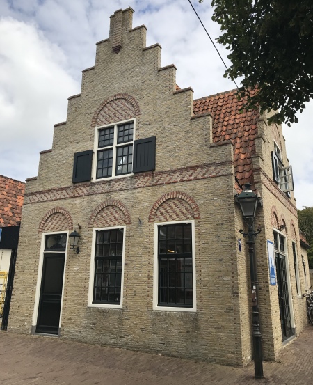
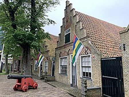
Striding along Torenstraat, we came across examples of Commandeurshuizen (Commander's Houses). The walls are made of small Frisian bricks from brickyards in the Frisian towns of Harlingen and Makkum. Wealthy ship captains, the "commandeurs", built these houses from the second half of the 17th century. The beautiful Amsterdam-style stepped gables and the arch-shaped ornamental brickwork above the windows and doors show that there was good money to be spent. I couldn't help but cast my mind back to the nearest town to where I grew up, Whitehaven. It too contained many capatin's houses, built in the Georgian style.
 Westerkerk |
 Commandeurshuizen |
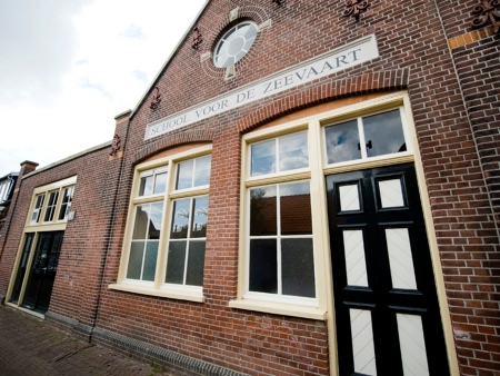 De Oude Zeevaartschool |
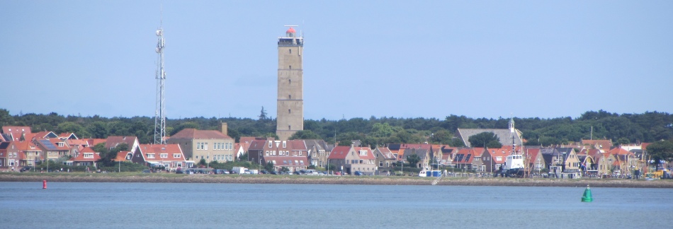
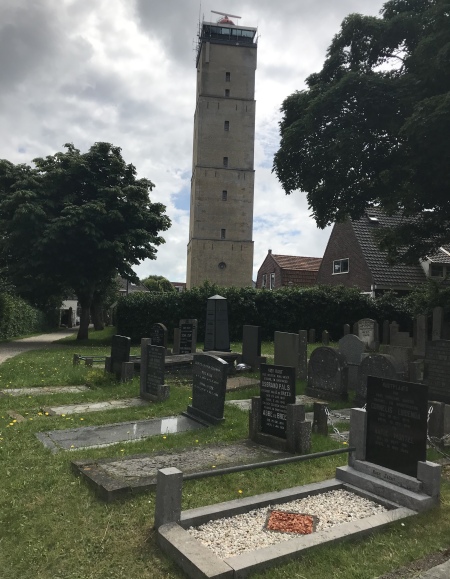 Vuurtoren Brandaris |
We then entered the main square. Towering above us in the centre of the square was the Vuurtoren Brandaris. This Terschelling lighthouse is the oldest lighthouse in the Netherlands. In 1323, the town of Kampen (at the head of the Ketelmeer) commissioned the construction of a lighthouse. This was intended to guide sailors between Vlieland and Terschelling, on their route from Kampen via the Zuiderzee (now the IJsselmeer) to the North Sea. This became the first Brandaris. However, the tower was built too close to the sea, and on 22nd January 1593 the tower collapsed.
In February 1593 it was decided that a second Brandaris had to be built, this time inland. This tower also failed in October 1593, when it collapsed during construction, probably through the use of bad stone and sloppy processes. The current tower dates back to 1594. In 1837 the Brandaris became the first Dutch lighthouse with a turning Fresnel lens. In 1917, Philips began to develop a new lamp. This eventually became an enormous light bulb with a diameter of thirty centimetres, the "Brandaris lamp". This was first used on 13th July 1920.
The seven floor tower itself is 53.66 meters high, the light being 55.5 meters high. The light of the tower is visible in a radius of 29 nautical miles; about 54 kilometres.
We continued on our walk around the town, then headed back to the ferry terminal early in order to try and get an earlier ferry back, primarily aiming to catch the fast ferry. The lady on the desk altered our tickets by hand, and didn't even charge us extra. Soon we were shooting the waves back to Harlingen on a high speed catamaran, averaging 31 knots.
Our final meal at the Nooitgedacht was again most enjoyable.