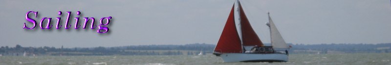
In the distance the Orwell Bridge gracefully arced across the river. To our right, an old deep-water channel had once existed at King John's Ness below Pond Hall. It was because of this deep water that John Barnard, who had one of the St Clements shipyards, moved here after he won a contract to build large men of war for the Admiralty. He built three men of war, the largest being the 854-ton
HMS Hampshire in 1741.
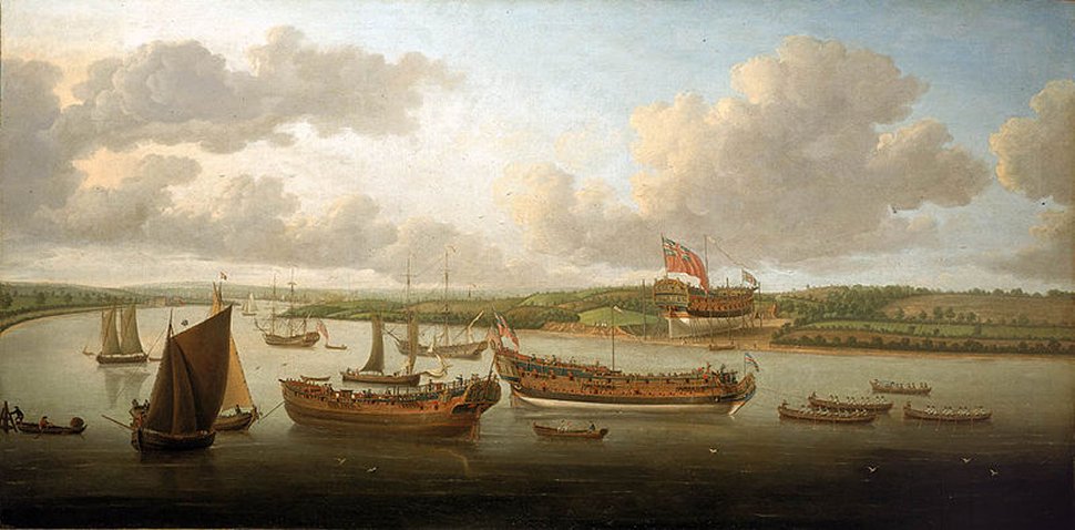
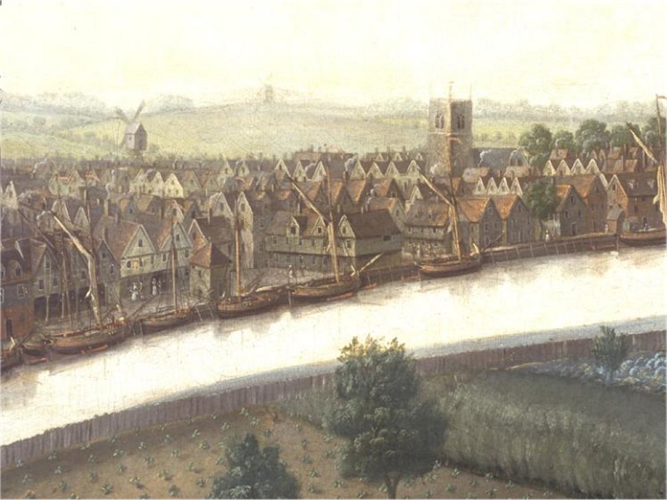
"Launch of a Fourth Rate on the Orwell" by John Cleveley the Elder
|
A painting by John Cleveley the Elder entitled "Launch of a Fourth Rate on the Orwell", depicts John Barnard's
Hampshire being built at King John's Ness. Also in the picture are two other ships built by Barnard, namely the
Biddeford, shown being towed down to Harwich to be rigged out, and the Granado.
Freston Tower to our left has various claims for construction dates, ranging from the 15th to 17th centuries, though and the current owner suggests the tower "was built in 1578 by a wealthy Ipswich merchant called Thomas Gooding". On the shores below the tower, the 1953 floods revealed 13th/14th century kilns, which were used for creating peg tiles.
At the start of the Freston Hill, a thousand-year-old lane leads down to Stumpy Lane Wharf, which existed in 1757. The 19th century farm wharf was in ruins by WWII when a slipway and base was built here for army landing craft.
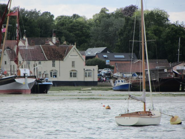
The road to Shotley skirts Red Gate Hard, a place where barges loaded goods from the Wherstead farms until about 1925. A ferry once crossed from here over to Pond Hall.
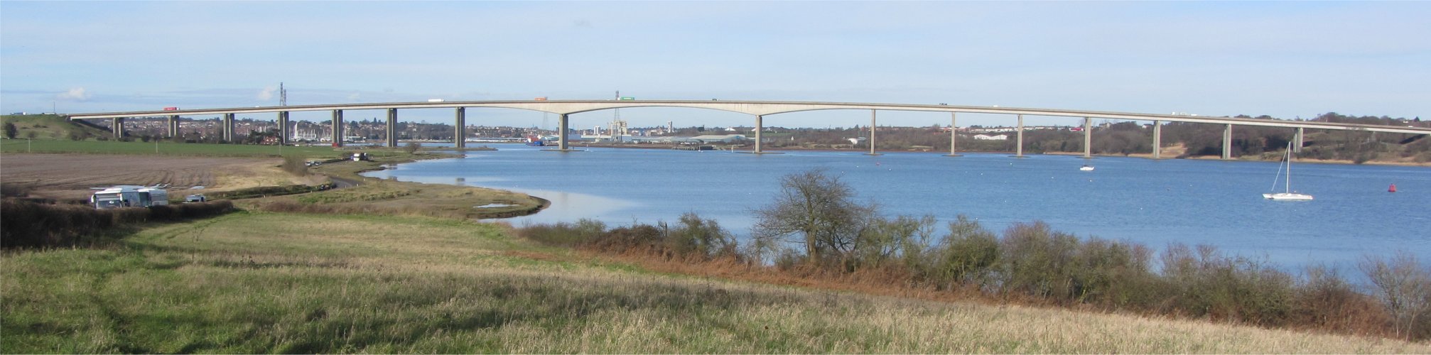
And then we were gliding below Orwell Bridge, whose construction commenced in October 1979 and was completed in December 1982. Built on pilings sunk 40m into the river bottom, the bridge has a main span of 190m which, at the time of its construction, was the longest pre-stressed concrete span in use. The total length is 1,287m from Wherstead to the site of the former Ipswich Airport. The width is 24m with an air draft of 43m. The bridge is constructed of a pair of continuous concrete box girders with expansion joints that allow for expansion and contraction.
Not far past the bridge, by Bourne Bridge, a dock was cut in front of the Ostrich (now the Oyster Reach, and incidentally where Rosie and I had our wedding meal with a small group of family and friends) in 1787 to load trees felled in Wherstead Park. Until about 1910 barges brought London muck for the farms and went out with stackie freights of straw and hay. Up until 1938 the barge
Twilight came once a year to load chestnut stakes. The Long Hard to the south of Ostrich Creek was used by Dutch barges before 1914 to unload cheese to avoid paying harbour dues.
The port of Ipswich was quite busy. A large gravel works stood on the left bank, not as large as its Ostend equivalent, and the right bank contained several ships having ballast removed, grain poured in, and powdered cement poured in to mention a few.
The lock to the inner basin was no problem and soon we were into the Haven Marina. I checked into the harbour master's office, where a squat fellow with unruly hair and a strong Suffolk accent was in heated debate with the young receptionist.
"Well, my mate, he say there be plenty of room on pontoon C for my boat," he blurted out.
"I'm sorry, but you can't use pontoon C," replied the exasperated woman.
"Well, thar's a funny thing. He say I can. Plenty o' room he say," he insisted.
This loop repeated itself a few times before he went off, presumably to find his friend. I later discovered he was trying to berth on the fuel pontoon.
Thankfully our berth allocation was totally painless. I returned to
Duonita, and had a chat with the woman on the motor boat next to us; her husband had helped us with our lines when we arrived. They were on a three-week tour around the East Anglian coast, and had set off from Portsmouth, and stopped of an Eastbourne on the way. Sadly, the fuel they took on board there must have been contaminated, since their engine had hiccupped all the way from there. Their fuel had since been polished, but they were now waiting for new fuel filters. "It could be three weeks," they had been told by a marine engineer.
At last, we could say we had arrived into Ipswich, the town where I had been living for the last 51 years. The town had an interesting past - a time to reflect on it.
The River Gipping enters the town at Handford Bridge, the area around which the Gipping at one time split up into several channels which wound through a delta or flood plain of marshland to enter the tidal Orwell at several points. The largest of these Gipping channels ran through the Portman Road and Princes Street to link up with the tidal water at Stoke Bridge. In the 19th century the Gipping marshes were bought by developers and built over. That part of the Gipping was piped underground while most of the Gipping was diverted into the top of the tidal Orwell. When the spiral underground carpark was being dug out, an underground channel was broken into, resulting in much flooding. The Handford water mill worked where the present Alderman Canal ends until about 1888, and lower down at Stoke, the Stoke Mill, a tide mill, worked until around 1850.
The River Orwell commences at Stoke Bridge, though the sea reaches up as far as the Handford Sea Lock. The name Orwell appears to be Anglo Saxon, meaning 'river near the shore'.
The Romans appear to have had estates all around the upper reaches of the Orwell, but Coddenham was the only Roman town in the Gipping valley. It was the Anglo Saxons who started a settlement around 600AD on either side of the ford linking Stoke to the main part of Ipswich. The name probably came from 'Gippswic' meaning the Gipping Market, and it was as a market centre that Ipswich first took shape.
Traces of early Saxon quays, little more than simple wicker revetments, were excavated along the shore line that followed the present College Street and Key Street. The medieval town of Ipswich continued to grow and ships from the Orwell quays sailed all over northern Europe and as far south as Spain. As ships steadily increased in size there was a need to create quays in deeper water so the process of reclaiming the mudflats and pushing the quay frontage into deeper water began.
Ipswich became a self-governing borough by a charter granted by King John in 1199. This charter effectively gave the River Orwell to the people of Ipswich for all time, making it one of the few British rivers which does not still belong to the Crown.
Ipswich trailed Dunwich in 1279 when it had thirty great ships to the latter's eighty. With Dunwich's decline in the Middle Ages the town built up a sizeable fleet. Its facilities were such that in the 14th century Edward III and the Black Prince fitted out 500 ships here for the Calais expedition.
In 1500 it became a King's Port, one of only eleven leading ports to enjoy trading privileges. By the Elizabethan era, when England was starting to create the first overseas empire, Ipswich began to make its name as a shipbuilding centre. It was called 'the shipyard of the Thames' and was launching 10-12 new ships every year, all built in good Suffolk oak. By 1673 Ipswich was turning out around twenty new ships a year.
"1753 View from Stoke Hill" by John Cleveley
|
However, Ipswich slipped into a decline during the 18th century; the silting beside the quays coupled with the increasing size of ships made the port difficult to reach. The practice of off-loading ships anchored in the Downham Reach just above Woolverstone increased, but was an expensive practice. There was talk of building a new port in Downham Reach, but the River Commissioners, who met for the first time in 1805, decided to hire a gang of labourers to dig away the mud which was blocking the channel to Ipswich. Progress by hand labour was slow, so a subscription was raised to build a 'steam dredging engine'. The thousands of tons of spoil were used to fill in the low ground in Stoke and St Clements.
The deepening of the channel to Ipswich did not save the town's shipbuilding industry. Jabez Bayley started to lose money on his ventures from the Halifax Yard on the Wherstead Road in the early 19th century. The Elizabethan shipbuilding area of St Clements, which had a slipway just south of Coprolite Street, was the last yard to build wooden ships for the ocean trade, and this ended with the brigantine
Clementine from William Bayley's yard in 1885. After this Bayley and the other Ipswich yards just built wooden sailing barges and other small craft.
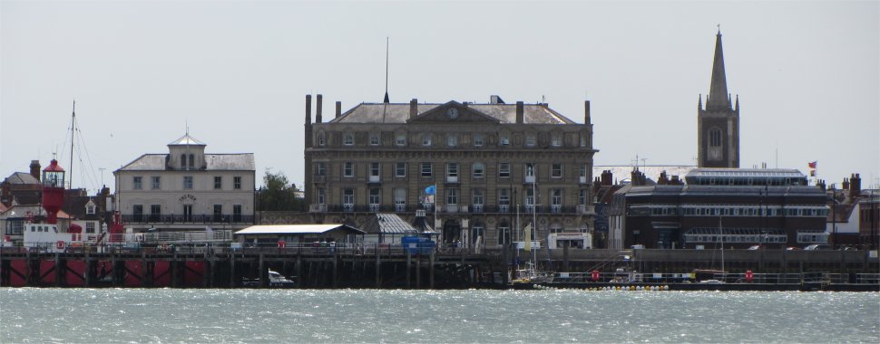
Meanwhile, business people were no longer content with a dredged channel with 12ft of water, they wanted the actual port improved. In 1836 a meeting was held, which included the Ransome brothers and John Chevallier Cobbold, and it was agreed that a wet dock should be built at Ipswich so that ships could be floated away at the quays and larger vessels could use the port. Thomas Palmer was commissioned to create a non-tidal dock by damming up the old channel, fitting a lock, and digging a new channel, the New Cut, through the low land at Stoke to allow the fresh water from the Gipping to drain out that way. In 1842, the first ship, the trading sloop
Director owned by John Cobbold, left through the lock gates loaded with grain. When it was opened, this was the largest enclosed wet dock in Britain. The old Customs House, built in 1844, proudly stands on the Common Quay.
Apart from giving access to world trade and shipbuilding, the Orwell provided the town with another lucrative industry during the 19th century, coprolite. This fossilised animal dung was dug up in great quantities along the Orwell-Deben peninsula and ground down to form a fertiliser. By 1877, 10,000 tons were being shipped each year. The industry is remembered in Coprolite Street.
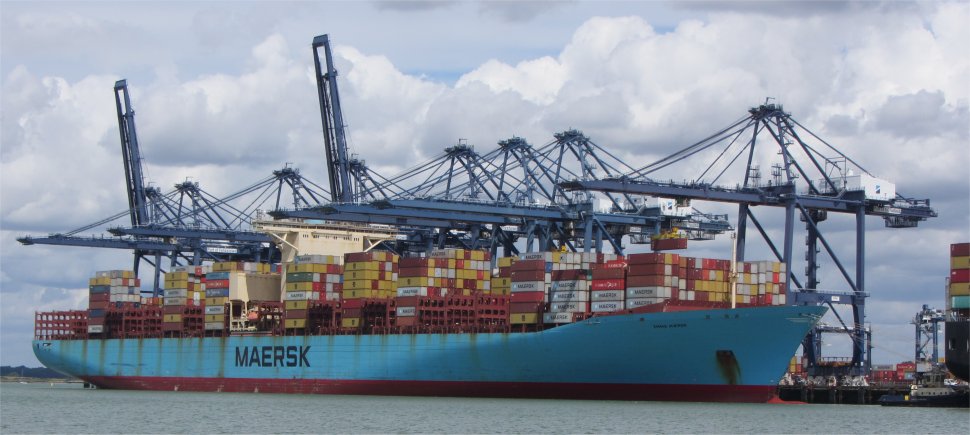
The size of ocean-going ships continued to grow, and the Dock Commissioners laid buoys in Butterman's Bay allowing them to discharge some of their freight before going up to Ipswich. Decades were spent discussing an alternative to the Butterman's Bay buoys, and it was not until the 1920s that they actually built Cliff Quay. Later, the West Bank ferry and container terminal was built on the Wherstead Road side of the river. Once a year the river is dredged using a survey vessel with sonar to measure how deep the water is coming up the estuary. The depth is kept at 5.6 metres when the tide is out and at high tide there is usually between 3 to 4 metres more water in the river.
Today, the bulk of commercial shipping berth on Cliff Quay and the West Bank terminal. The Port of Ipswich has 1640m of quay on the river below the Ipswich Wet Dock and 64,000 square metres of covered storage. The port's cargo is generally raw materials such as timber, cement, grain, fertiliser, animal feeds, aggregates, liquid bulks, containers and roll on/roll off container traffic.
Only a timber ship now regularly enters the wet dock to deliver timber. The10.60 hectares wet dock is primarily used by leisure vessels with berth for 385 vessels. The water level is kept at 6.4m.
I wandered ashore to use the facilities, and noticed a large crowd sitting outside the Last Anchor bar/restaurant by the marina. On my return I commented to an elderly lady who was returning from her shower, "Must be a big yacht reunion," nodding towards the large group.
"Oh, me and my husband will be up there with them in a short while. Most of them know each other, but this will be our first time with them."
"Are you all from the same marina, or do you all have similar vessels?" I enquired.
"No, but we all bought yachts from the Norfolk Yachting Agency, and they organise these big get togethers. We keep our boat at Great Yarmouth, but the boats come from many marinas in Norfolk."
I thanked the lady for enlightening me, and she boarded her vessel to dry her hair.
Rex and I headed off to Tesco Express on the other side of the harbour basin, and purchased enough provisions to see us out for the rest of the trip. On our way back we admired the determination of a gull that dropped a mussel from 3m onto the road, pick it up and repeat the process until it managed to gain access to the juicy contents within the shell.
In the evening we dined in the Last Anchor. The food was amazingly good, in fact so good that Rex went and personally congratulated the chef. The young waitress who served us was a charm. We discovered it was her third day in the job. We informed her lords and masters that she had done a splendid job too.
In one of Rex's crafty fag breaks, he had spotted three signs adjacent to each other, all just centimetres apart, and all conflicting each other. Well, this is Ipswich after all.
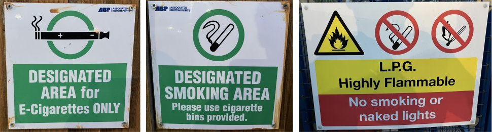
Smoking Conflicts, All Centimtres Apart
|
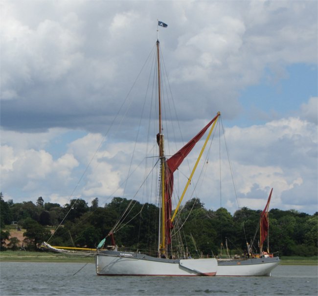
On the way back to
Duonita we spotted a large vessel under tarpaulin, obviously being restored. We learned it was
Glala, a classic motor yacht built by A.R Luke before the First World War. She had had an eventful history that included service with the Royal Navy and the National Fire Service in the 1940s.
Glala started life as
'Doris' in 1915, and was built on the River Hamble near Southampton.
Doris was commissioned by a wealthy Argentinean diplomat, Aaron de Anchorena, to cruise the Amazon. At the time, it was among the first diesel motor boats, featuring twin-screw propulsion and a wooden design. It changed hands numerous times, counting industrialist Sir William Verdon-Smith and MP Ronald Nall-Cain among its owners. But arguably its most famous former master was Sir Alan Cobham, who christened it
Glala, by combining the names of himself and his wife, Gladys.
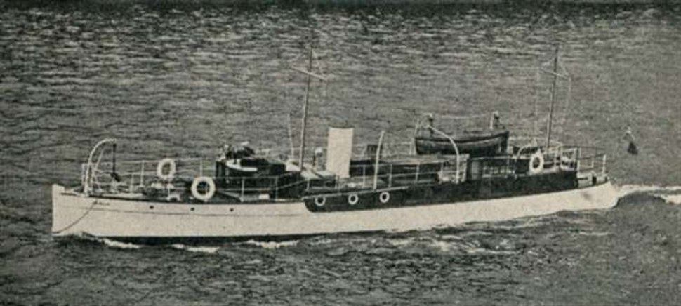
Glala on the Eve of War 1939
|
Engineering firm AEC bought
Glala in 1938, before it was requisitioned by the War Department at the onset of the Second World War in 1939. She started the war as a harbour defence vessel in Sheerness and patrolled the Thames estuary. However, the vessel's finest hour was during Dunkirk in 1940.
Glala made a number of trips during the evacuations, and came back home loaded with men from France.
Since 2017,
Glala has been under the ownership of Kathy Norris and Andrew Robson. The opportunity to own a beautiful and unique Edwardian motor yacht, a vessel in the National Historic Fleet and one of the largest of the Dunkirk little ships, was too good to pass up. Restoration work is still ongoing.