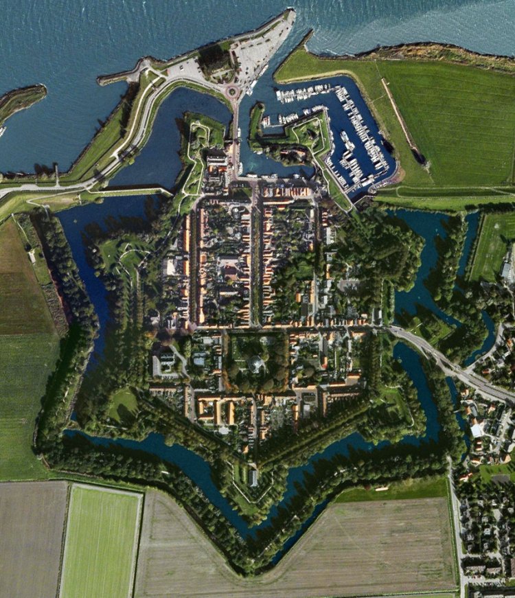
 Aerial View of Willemstad |
I booked us into the marina for another night, topped up the fresh water. Then it was a case of scanning the internet for information on our access into Dordrecht through the road and train bridges that crossed our path. Thunder growled in the distance, and a dark wall of cloud approached. Then, all of a sudden, we were in the midst of a squall, rain hammered onto the decks and a strong wind rocked Duonita. Just as quickly it passed through and left us in sunshine.
At noon, we headed off to walk the town's fortified walls, crossing the moat at the Westbeer. It was from here that we turned right and picked up a path that traced the top of the old fortifications, and skirted the Gracht or moat that surrounded the town. It soon became apparent near the first bastion that we came across that evidence of military activities still survived. And, as with a lot of the Netherlands, signs of military occupation from more recent times were visible.
The seven bastions along this path around the town were named after the seven provinces of the Dutch Republic: Groningen, Overijssel, Friesland, Utrecht, Zeeland, Holland and Gelderland. The net result was a town completely surrounded by a city wall in the shape of a 7-pointed star completely surrounded by two concentric "canals", one of the most attractive examples of the old Dutch system.
It became abundantly clear during the First World War that fortresses were completely outdated. In the run-up to a new defence system, there was no longer room for most fortresses. The garrison left the town in September 1922, which meant that an important source of income had disappeared. By Royal Decree of 28th May 1926, Willemstad was abolished as a fortress. The population campaigned for the preservation of the fortifications.
Willemstad briefly became a fortress again during the Second World War, but now as part of St�tzpunktgruppe XXXIV of St�tzpunktgruppe Ooltgensplaat, an inland part of the "Atlantikwall". In 1943, the Germans built two reinforced concrete bunkers for coastal artillery of the type 669 on Bastion Holland, as well as positions for anti-aircraft guns, concrete shelters, ammunition stores and an observation/command bunker on and in Bastion Gelderland. We passed these two huge bunkers on the Holland Bastion, commanding views over the Haringvliet and Volkerak, where they could control passage through these stretches of water. Now they were mere huge, concrete shells awash with muddy water surrounded by a quagmire after the recent downpours.
We carried on along the path, pausing to watch a digger scooping out duckweed from one of the small canals that ran inside the steep earthworks. At the Zeeland Bastion, we dropped down and headed across to the Mauritshuis and its Museum de Heemkundezolder (Local History Attic). This impressive building also served as a tourist information point.
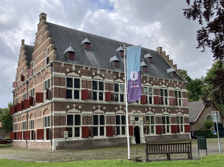 Mauritshuis |
The Mauritshuis was the town hall of the municipality of Willemstad from 1973 to 1997. The national monument was then given another function. Weddings can now take place in the former council chamber. Heemkundekring De Willemstad uses the Mauritshuis for a permanent exhibition in the attic, providing a comprehensive guide to the history of Willemstad and its fortress, the surrounding forts, the Zuiderwaterlinie and the Volkeraksluizen.
The pioneers, who in 1565, full of courage, entered the newly drained Ruigenhil polder to reclaim it and build a village there. They must have hoped for a better future for themselves and their children. However, these were difficult years, too difficult for many. During the All-Saints Flood of 1570, the dike failed and the polder was flooded. A year later the Water Beggars came and plundered the Island, chased away the pastor and took all the grain and livestock with them. They were driven out by Spaniards who also lived there. Arsons, hostage takings and extortion were commonplace in those first years. The Water Beggars eventually gained the upper hand and used the new polder as a base for their further forays. Things got better when, in 1583, Prince William of Orange had the village walled and built according to a design by Abraham Andriesz, and made it into a fortress. However, the lonely farms located in the polder remained targets for groups of plundering Spaniards throughout the Eighty Years' War.
In 1587, the city council of Willemstad, as the village of Ruigenhil had been called since 1584, placed itself under the government of Prince Maurits. He would take care of the maintenance of the fortress and all kinds of war expenses in exchange for the proceeds of the tax money. He also contributed to the construction of a town hall and a church - the first in the Netherlands built for the Protestant religion. In 1615, Maurits became Lord of Willemstad, when Willemstad was separated from the Marquisate of Bergen op Zoom with the Ruigenhil polder, and became a separate seigneury.
Willemstad residents learned to live together with soldiers of all nationalities. Until a barracks was built in 1748, they had them in the house or in soldiers' huts in their garden. They themselves also had to arm themselves in times of war and serve in the civil guard.
Once during its existence as a fortress, Willemstad underwent a siege, namely in 1793 when a French army of more than 8,000 men tried in vain to conquer the fortress.
In January 1795 the French returned and Willemstad had to capitulate by order of the States General.
During the Batavian/French period (1795 - 1813), Willemstad remained orange-minded and stubbornly clung to acquired rights, but the new era was unavoidable. Her separate status as falling under the government of Orange was over. Under initial protest, but later at his own request, Willemstad was assigned to Batavian Brabant in 1797.
Afterwards there were also wars, but these remained far from Willemstad. Their only consequence was an increase in the garrison and sometimes the declaration of martial law. Other than that, life went on quietly. People liked to leave everything as old and familiar. Willemstad has never exploited its favourable location on the Hollands Diep. Not even when the fortress was closed in 1926. Then it was finally possible to build outside the ramparts, something that was not allowed before. Nothing came of the plans for the construction of a tram port and an industrial estate. An ambitious expansion plan also failed. The well-preserved ramparts, now a national monument, were leased by the government in 1935 to the Menno van Coehoorn Foundation for thirty years and subsequently transferred to the municipality of Willemstad.
The German occupiers turned Willemstad into a fortress again during the Second World War (1940 - 1945). The "Fortress Willemstad" became part of the German coastal defence. In November 1944, Willemstad was under English artillery fire for days. During a short truce, the population was able to leave the city and were relocated elsewhere in liberated Brabant. Only long after the entire country had been liberated could the evacuees return to the badly damaged Willemstad.
Hardly recovered from the misery, Willemstad was struck by two disasters in 1950. A heavy tornado raged over the city and caused a lot of damage. Just before the restored domed church was to be put into use, a fire broke out. Only the walls of the beautiful building remained.
The Ruigenhil was also affected by the flood disaster of 1953. The subsequent Delta Works, including the construction of the Volkerak locks, was a stimulus for employment and housing construction, as well as for recreation and water sports.
In 1997, Willemstad ceased to be an independent municipality. Since then, it has formed the new municipality of Moerdijk together with four other former municipalities.
The historic accounts were brought to life on a more human level. In one instance, a diary written by a governor gives an account of how a handful of volunteers put their lives at risk to repel an assault on the Oostdijk in the direction of Fortress Bovensluis, and became heroes of the day. Similarly, an account by a nurse described the benefits from bringing soldiers into the town.
The importance of nearby forts was also highlighted. In 1747, when the French invaded the country during the War of the Austrian Succession, a number of earthen forts were hastily built on the dykes around Willemstad. Most of these are still visible in the landscape.
To prevent an invasion from the sea by the English, Napoleon had two forts built on either side of the Volkerak in 1811: Fort Prins Frederik and Fort Sabina. Fort de Hel was built to cover Fort Sabina and the access to the dykes. Rex, Meryl and I had walked to Fort de Hel on 21st June 2014, just short of ten years earlier.
Due to the ever- more powerful artillery, it became necessary to defend a fort from a greater distance. In 1860-62 the Fort Bovensluis was built on the Oostdijk, to defend the dyke up to the port of the Noordschans and to cover fort Fort Sabina. Opposite Willemstad, next to the harbour of Numansdorp, the Fort Buitensluis was built to defend the waterway.
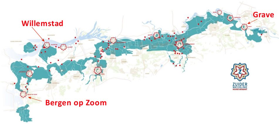 Zuiderwaterlinie, showing Network of Forts, Natural Waterways in Light Blue, and Areas for Inundation in Turquoise |
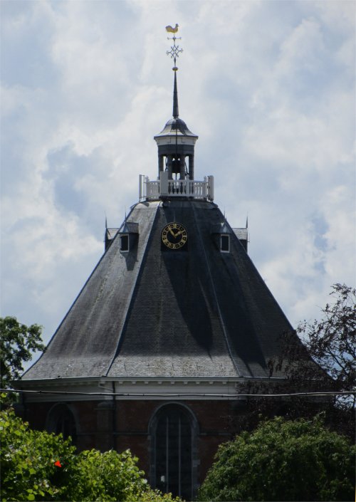 The Spire on the Dome Church |
A short film covered the horrific 1953 flood that wreaked devastation across whole swathes of Holland.
Situated quite close to Willemstad were the Volkeraksluizen, which naturally were another topic covered in the museum. The locks were built as part of the Delta Plan. A secondary dam had to be constructed in the Volkerak to close off the Oosterschelde and the Haringvliet. However, the closure of the Volkerak, which was planned in 1969, would also block the only shipping route between Rotterdam and Germany on the one hand and Antwerp and France on the other. This was deemed unacceptable. It was therefore decided to build a lock complex in the dam that was to be constructed.
The first two inland waterway locks were put into use in 1967. In 1977, the complex was expanded with an extra lock for inland shipping and a separate recreational lock for yachts. In addition, an inlet lock was built.
The commercial locks each have a length of 325m and a width of 24m. The yacht lock is 142m long and 16m wide. To allow extra high ships to pass the A29 motorway, a bascule bridge is located over the eastern lock chamber. Approximately 110,000 commercial vessels with a loading capacity of 200 million tons and approximately 148,000 yachts pass through each year.
The total area of the complex is approximately 300 hectares, of which 200 hectares are water and 100 hectares are land. In 1988, this complex was listed in the Guinness book of records as the largest inland navigation complex in the world.
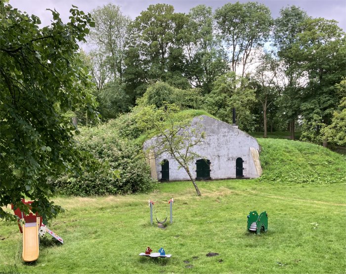 Gunpowder Magazine |
Continuing our tour, we headed off to the Gunpowder Magazines in Bastion Utrecht and Bastion Friesland. Furthermore, small wooden powder cellars for immediate use were constructed in the ramparts if necessary. The introduction of grenades made the powder magazines too vulnerable. They were therefore modified in 1884 and a wall of concrete blocks was built around the most vulnerable places and the earthen cover was improved. In 1890-1892, a new powder magazine was built to replace the powder tower in Bastion Friesland, the floor of which had long since been demolished, as well as in Bastion Holland. The latter was blown up by the Germans during their retreat in November 1944, after the ammunition had been cleared there.
We completed our circumnavigation back at the Old Harbour. The rest of the day was a mix of wind and showers- how predictable!
In the evening, we headed to town via the Outer Harbour. En route we passed by the Belgian Honour Cemetery.
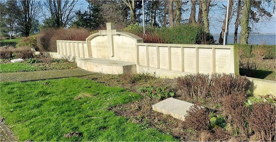 Belgian Honour Cemetery |
Close to Willemstad on the 30th of May 1940 the "Rhenus 127" sailed over a German magnetic mine, which made the overpacked ship with 1,200 prisoners explode in the middle. It broke in two and sank. However, most of the prisoners managed to save themselves and were able to get rescued and taken care of by the citizens of Willemstad. Almost 200 Belgian soldiers still drowned and most of them found their last resting place in this cemetery. Later on, a few other Belgian soldiers who died somewhere else in the Netherlands were also laid to rest here.
Underneath the cross on the left is mentioned:
HERE LAY TO REST 134 BELGIANS
fallen for their fatherland and ours
30th May 1940
We enjoyed another meal in the Rosmolen in the evening. On the way back to the boat, Rex gave an impromptu blues session on a white piano at the top end of Groenstraat. Crowds did not flock out of their houses to applaud.
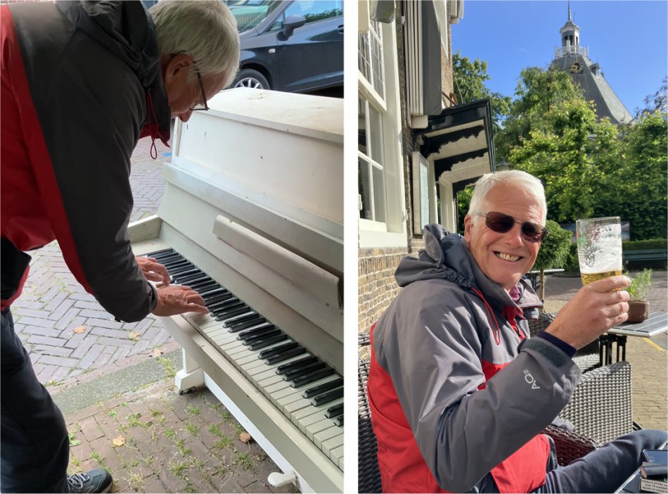 Rex Banging Out Another Number in His Impromptu Blues Session |