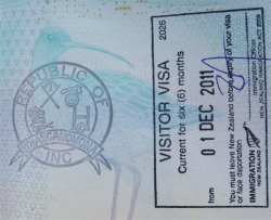
Republic of Whangamomona Passport Stamp
|
It was a gorgeous morning with dew glistening on the freshly mown grass. A "gossip" of hens was strutting around the campsite, hoping to scrounge some breakfast off me. Fat chance. I tried to leave camp, but my battery was dead. It is only a tiny battery in the Nissan I am driving, and I had been up to 1am typing my notes, flattening the battery in the process. The camp manager rallied to my aid with a set of jump start leads, and I was away.
I drove the short distance to Whangamomona Village, the only significant settlement on the highway, and known as the "Valley of Plenty". It was first settled in 1895. By 1898 there were 187 people in the district. During the early 1900s the settlement flourished but the great flood of 1924 started the settlement's decline and now it is almost a ghost town. The residents of this tiny settlement declared Whangamomona a republic in 1989 after disapproving of local government plans to shift the area's district boundaries. Since that time, every two years, in January, Whangamomona celebrates its Republic Day. Thousands of visitors gather there to receive their Whangamomona passport. Some interesting events take place at the Whangamomona Republic Day, such as sheep-racing, possum skinning, gumboot throwing and whip-cracking. Crumbs, I can't wait. The main event on Republic Day is the town's new presidential election! Among former presidents were Billy Gumboot the goat, elected after eating all the opposition's votes, and Tai Pouto the poodle, who stepped down after an assassination attempt. These folk know how to have fun.
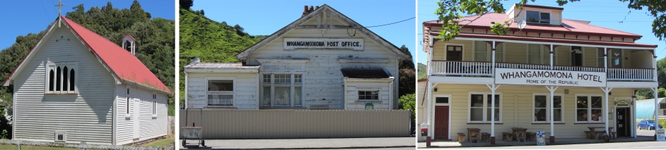
Whangamomona Buildings
|
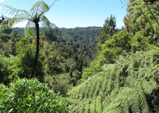
Lush View from Whangamomona Saddle
|
I popped into Whangamomona Hotel to have my passport stamped. Penny, the lady who had served me the previous night, did the honours for $1 which goes to local charities. We chatted about the highway and I had a little dig at the brochure which I had found misleading. "I couldn't find the poles at the Maraekowhai Reserve," I said. "No, you wouldn't, they are not there anymore." I also pointed out the misplacing of Nevin's Lookout on the brochure map. "That is why we don't stock that brochure anymore, it is all wrong. We keep telling them about it, but they won't listen. There is a Bridge to Nowhere, a Bridge to Somewhere, and then somebody called the bridge near here the Bridge to Elsewhere. It only took one letter to get it lodged in some brochures. We wanted it removed, but it is impossible, no matter how many times we try." I could totally understand her frustrations. She gave me advice about the rest of my journey along SH43, and mentioned a good museum to visit just outside Normanby. Like many New Zealanders, she had relatives in the UK, and was familiar with place names that I mentioned. She wished me luck on my travels, and I was off.
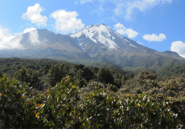
On the way out of town, the 270m Whangamomona Saddle provided a spectacular view of the boundary of the Patea and Wanganui River watersheds with beech and podacarp forest flanking the highway. Soon afterwards, I crossed the 270m Pohokura Saddle. Named after a Maori Chief, Pohokura was first settled in the late 1880's. In those early days the road over the saddle was so bad that it took three days to pack supplies from Stratford. Now sealed, the saddle provides a view of the valley, once home to the railway workers building the Pohokura tunnel.
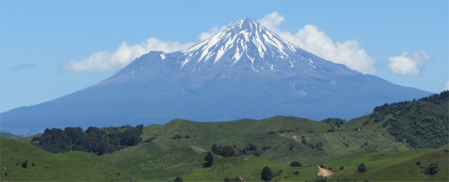
My First Glimpse of Mount Taranaki
|
I proceeded along the highway to the ragged 275m Strathmore Saddle, which on clear days provided a great vantage of the three volcanoes of Tongariro National Park: Ngauruhoe, Ruapehu, and Tongariro to the east, and the snow-topped cone of Mount Taranaki to the west. This point has traditionally been considered the start of the "Back Country". East of here, the dairy farming of the volcanic ring plain and rolling hills and valleys changes to mainly sheep and beef cattle farming. As I reached the top of the saddle, my breath was taken away by the stunning view of Mount Taranaki, almost a perfect cone with a lump attached to one side. There was cloud over to the east, so I missed out on views to the peaks in Tongariro National Park. Apparently the saddle lay close to a fault line, and in the surrounding hills there was still some evidence of the "shell rock" containing fossils of marine life deposited when the land was the ocean floor millions of years ago.
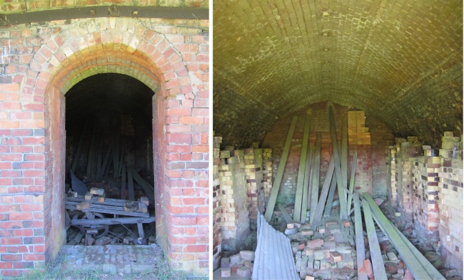
Douglas Brick Kiln
|
Beyond the saddle, I drove to Douglas Village. Like most small Taranaki settlements, Douglas Village had flourished and waned since the first land clearings and settlement around 1890. It finally declined with the closure of its dairy factory and store. For over 60 years the Douglas Brickworks was a major producer of blue clay bricks, and an employer of local labour. In 1924 the brickworks diversified into field tiles, and the four inch tile two feet long became the most successful product. However, the Napier earthquake caused the government to turn away from brick buildings, and the depression also caused a drop in demand. The Brickworks closed in 1981, and the 20m high chimney that had wafted smoke over Douglas Village for years was finally demolished in 1985 for safety reasons. The Douglas Brick Kiln, classified by the Historic Places Trust, is the only one remaining in Taraniki. There are very few remaining brick kilns in New Zealand.
Then it was a straight run down into Stratford, with Taranaki dominating the skyline. When I had first set eyes upon it on Strathmore Saddle, it stood alone in majestic beauty. Now clouds were swirling around to hide its secrets.
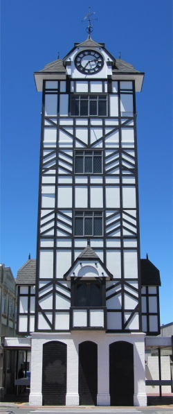
Stratford Glockenspiel
|
Popular as the gateway to the Egmont and Wanganui National Parks, Stratford played upon its namesake, Stratford-upon-Avon. The town contained many Elizabethan features and all its streets were named after Shakespearean characters in 37 of his plays. The central icon was the mock-Elizabethan Clock Tower, New Zealand's first glockenspiel from which a life-sized Romeo and Juliet appeared four times a day accompanied by recordings of Shakespearean quotes. Thank God the UK site doesn't go that far.
Dawson Falls
|
As a European settlement, the Stratford district was carved out of dense rain forest in the late 1870s to prepare for dairy farming on the rich volcanic soil. To create the Stratford township, 40 sections on the north bank of the Patea River were sold a year after they were surveyed in 1877. At that time the Taranaki Land Board decided on the name "Stratford", a suggestion from a Mr Crompton as a name for this new settlement. Originally this settlement was known as Stratford-upon-Patea after Shakespeare's birthplace Stratford-upon-Avon. Stratford quickly thrived and was nicknamed the "Chicago of the South" because of its rapid development. As early as 1897 the town had electricity, a railway station, a bank, a post office, and its share of hotels. A few years later in 1900, Egmont National Park was created with Stratford as its gateway.
I had a walk through town, which didn't take long, it is basically a crossroads town, Broadway being the main drag. Spotting a hairdresser's, and feeling my hair needed drying nowadays after a shower, I nipped in to get a cut. "What can we do for you?" asked the woman at the desk. "Could I have a number 1 cut, please," I answered. "Sure thing. Take a seat," she said, pointing to one of the empty chairs in front of a long mirror. I heard voices, then someone explaining to a young girl that a number 1 is basically a shave one up from totally bald. Eventually the young girl got the message, and she nervously wrapped a gown round me and picked up a shaver. She was obviously in training, and I was the guinea pig. Another girl walked up and told her she had to attach a fitting, otherwise I would have no hair at all, and duly attached the correct fitting for her. The girl started, but soon started to get flustered, calling the other girl for help. The more experienced girl showed her what to do and then left her. My God, I thought, what am I going to end up with today. When the apprentice started attacking the top of my head, which has little hair to start with anyway, she started ragging the shaver vertically over my head. The attachment was now ploughing grooves across my top. I patiently told her what she was doing wrong; I even took the shaver off her and showed her how to shave using the back of my hand as an example. She still didn't get it, and eventually the manageress stepped in to finish it off and show the technique to the girl. "We'll have to go back to square one with the manikin," she advised the girl. The poor lass were embarrassed. Hmmm... my daughters manage to shave my hair without any tuition at all. As I left my mind went back to another
zany barber episode in San Francisco, but there I was concerned for my life.
It's a Long Walk Through the Bush to Reach Taranaki
|
For some reason I felt whacked, so I went off to find a campsite. Fortunately there was one in town, so that was optimum choice for the time being. I entered the office, a room with countless mugs and chamber pots hanging from its ceiling. "Good afternoon," said the elderly lady as she entered and stood behind the camp reception desk, "where are you from?" I picked up the accent straight away. "Originally about a 100 miles west of where you're from," I replied. "And where's that?" she asked. "The Lake District." "Whereabouts in the Lake District?" "Whitehaven," I answered. "Oh, I know Whitehaven quite well," she said. The lady originally came from Darlington, but moved to New Zealand 40 years ago. Before emigrating, she had worked over on the northwest side of the country, hence she knew it well. She was very much into country and western music, and was great friends with a singer who tours with George Hamilton. She often travels with him on his tours, selling CDs and memorabilia. The singer had done a circuit around New Zealand, and he also did quite a few gigs in East Anglia, so she knew Ipswich and the surrounding area quite well too. She would like to do more, but she is tied to the campsite (I think she was the owner). What a small world we live in.
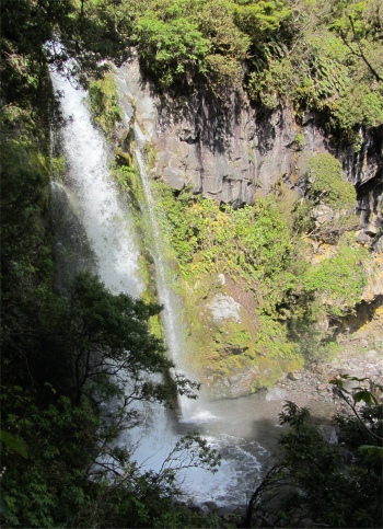
Boredom was starting to set in, so I drove up to Dawson Falls, just to get a closer look at the mountain. The air up at the falls was clear, and I could see for miles and miles across southern Taranaki region. Dawson Falls was surrounded by thick bush, which gave way at higher altitudes to scrub, then tussock. The volcano looked awesome, but I would now have to think carefully about whether to climb to the summit, or just tackle some of the many trails which wind around its slopes. I was now feeling like yuck, I had aches and stiffness from my pummelling under the tree on the Whanganui River. I gazed at the big hill, and decided to sleep on the matter.
I walked a short way down to the thundering falls, and then drove down the long slopes back to Stratford. My strategy tonight is just cook a meal, type notes and have an early night. I may even open a bottle of beer.