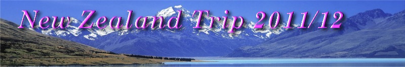
 The Bush - "Goblin Forest" |
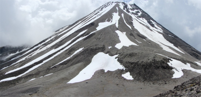
Reaching 2518m above sea level, Mt Taranaki is New Zealand's most perfectly formed volcano, rising dramatically, straight out of flat, emerald green pasturelands and wearing an attractive skirt of rainforest on its lower slopes. Apart from one small bump, a subsidiary vent called Fantham's Peak, the mountain's cone is beautifully symmetrical. This peak has a symmetry and profile that resembles Japan's Mt Fuji. Indeed the mountain starred as a stand-in for Mount Fuji in The Last Sumarai. When I first caught site of it as I approached along SH43, I was stunned by the beauty of this majestic and sacred peak. This old fellow was around 120,000 years old, and last erupted in 1775. Volcanologists agreed that the mountain was "dormant" rather than extinct. It ruled supreme, standing tall above the surrounding landscape. Beside it were two other eroded volcanoes of an earlier era: Kaitake and Pouakai.
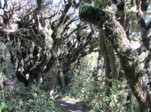
 Plaque on Hillary Seat |
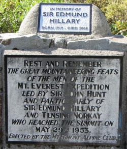
 Scrub Approach to Fantham's Peak on the Left |
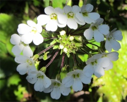 Scrubland Flower |
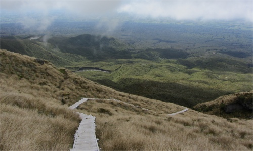 Wooden Steps on the Tussock |
I drove back through succulent bush up to Dawson Falls, where I sorted out my gear for the hike. I packed into my backpack warm clothing and a waterproof should the weather turn foul. Reports say that the weather up there can change in the blink of an eye, and people have lost their lives. Energy bars, biscuits and dried apricots plus plenty of water completed my essentials. There is a fine balance between how much to take, and how much I'm prepared to haul to the top of a mountain.
The hike began as a steady climb through dense bush. The men who blazed trails through this stuff must have been hard. On the lower slopes the bush was lush, and trees wore cloaks of thick green moss, the "Goblin Forest". Hosts of small flowers balanced the mass of green hues. A soft, green half-light pervaded all things. Penetrating sun shafts speckled the ferns and mosses with flickering light. The calm atmosphere was embroidered by the rich sounds of birds. The bush was high and so dense that I lost all sense of orientation; I couldn't see a thing apart from the continuous climb in front of me.
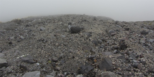 Scoria Slope |
From here, the climb was through scrub. It was a continuous climb with very little horizontal walking. I passed the Hooker Shelter, built like a sturdy wooden bus shelter, with a bench running all the way round the inside. This haven must be heaven when the weather catches unwary hikers out.
I forced my way onwards and upwards. Bees and flies were everywhere, the scrubland section was almost like an insect Grand Prix. These winged creatures would appear out of the scrub, zoom past me and disappear into the bush, with the high pitched scream of a racing car.
An hour of scrubland walking took me to tussock level. This was traversed by wooden walkways, or to be more exact, wooden staircases, to protect the environment I guess.
Then I reached the scoria. This is basically ash, pumice and sharp jagged rocks thrown out by a belching volcano. The route through this was marked by orange poles. Climbing this stuff was purgatory. On a slope ranging between 45�-60�, each time I put a foot down, it just slid back as the scoria gave way. At times it was a case of one step forward, two steps backwards. It was a sheer hard grind going up, and I was dreading having to come back down through the scoria, but I would have no option. The fine powder thrown up as I climbed got into my mouth and was very abrasive on my teeth. I was now enveloped in swirling mists, but they were "friendly" mists, not the type that warn of approaching foul conditions.
 Taranaki Appears out of the Mists After Sally Sent Her Text |
I walked over the pumice field to a crag of red twisted and tortured rocks, also volcanic output, which disappeared to unknown depths below. The whole area spoke "volcano". The red rocks were sharp and jagged, but I managed to find one to sit on, and just waited for the mists to clear.
I was in a world of my own when my mobile bleeped to inform me of a text message. It was from my eldest daughter, Sally. She just wanted to tell me she was thinking of me on this special day, and she sent me all her love. Incredible really, here I was on top of a mountain the other side of the world. I was deeply touched, and instantly replied telling her I was alone on this peak overlooking Mount Taranaki, and I thanked her for thinking of me and sent my love back. She responded to my reply, also remarking how incredible it was, and saying she was sure her mam was sitting there beside me watching the wonderful sight in front of me.
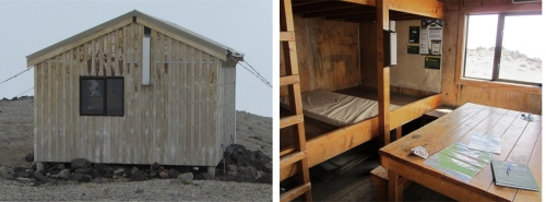 Syme Hut |
It was 30 years ago today, on a snowy morning in Ipswich, when I married Rosie. I sat and pondered all the "what ifs", but that doesn't get me anywhere.
I drank another bottle of water as I watched the world, and then went to visit the Syme Hut. This was a very sturdy wooden cabin, anchored to the ground by strong cables to prevent it being blown away by the strong gales that sweep in from Tasmania. There were two enormous bunks to one side, each bunk being 2m deep by 6m long, room for seven or so mattresses side by side.
From the visitors book I learned that the two lads I had met independently coming down through the bush and scrub were from Holland and the Czech Republic. They had stopped overnight at the hut. The couple who I had met coming down the scoria slopes were from Austria, and were just doing a day's hike like myself. I wrote my details in the book; there were now two British entries.
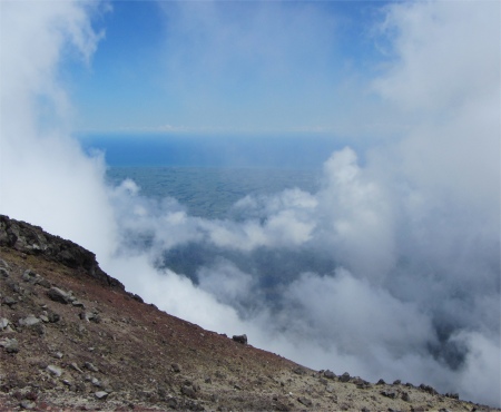 Tasman Sea to the West Through a Gap in the Mist |
I began the long descent. Going down the scoria was more of a precarious slide, occasionally ending up on my backside. Going up and down those slopes were equally as bad. I was grateful for the poles which loomed out of the mists at the right moment. I could hear a helicopter in the grey void, as it turned out rescuing another person who had slipped into one of the many gullies on Mount Taranaki.
The descent of the staircase over the tussocks strained my knees, as did the winding trail down through the scrub. I was glad to take a breather at Hillary Seat. Here I could sit back and look back over my route down the peak whilst listening to the soothing melodic birdsong.
The last leg down through the "Goblin Forest" was painful for my right knee; an old sporting injury was playing up. My toes grumbled but did brilliantly. Eventually I popped out of the bush, and a voice called out, "Did you get to the top?" It came from a portly woman standing next to a picnic table, her husband comatose on the bench. "I only went up to Fantham's Peak, not the summit of Taranaki," I replied. I described my hike. She was envious, her fear of heights preventing her from straying far into the hills. The couple were from Germany, and were doing a six month tour of the country. The lady had managed to take a sabbatical from the school she taught. We discussed our trips, our thoughts on New Zealand, campsites, and schools (my wife had been a teacher). Apparently her daughter had once visited Wellington, and returned with a husband. The couple went to visit their daughter's in-laws, and were greeted like long lost friends. Everybody in the village had heard all about them long ago, and they had been made to feel most welcome.
The woman discussed the latest moves in the schools back home, the current theme is inclusion. Basically people with learning difficulties are being integrated into standard schools. The down side is that they demand more time and resources, to the detriment of the more able youngsters. The up side is that the brighter ones can learn a lot more about social skills from those with learning difficulties. Whether it all works out or not, time will tell. We wished each other a Happy Christmas and good luck with our journeys, and parted.
I made my way back to camp, let the lady on the desk know that I had returned safely, and spent half an hour in the shower. Boy did that feel good. For a few moments I idly watched a girls rugby match in the sports field next to the camp. This country really takes its rugby seriously. Then it was down to serious business, sorting out some food.
Later on, in the communal kitchen, I met some familiar faces, a Dutch couple I had met at Taumarunui campsite. They too had travelled across on the Forgotten World Highway and thrown the misleading brochure away in disgust. They had canoed down the Whanganui too, but much further down the river. They had arrived in the country on the 2nd December, and were also spending three months here. Some relatives of the woman had moved out here 30 years ago, so visiting them had eaten some of their time up already. We discussed our future plans, and campsites visited. They had noticed that the site at Taumarunui did not have any of the usual "Do Not xxxx " signs common in many other sites. I can't say I noticed, perhaps I blindly ignore most of them.
All in all, I had enjoyed my day, despite the scoria traumas. It had been an excellent workout, eight hours on the mountain. No doubt I will have plenty more mountains to cover on my journey.