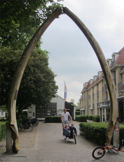
 Whalebone Arch |
As the ferry slipped out of the terminal, scores of parents and friends stood on an earthen embankment waving the youngsters off, some no doubt with a tear in their eye, others with joy and relief for some respite, and some waving to a child who was absorbed in some activity deep within the bowels of the ship, oblivious to their parents.
Rex did a splendid job of ordering coffees in Dutch, he was coming on by leaps and bounds.
The route across the Waddenzee to Schiermonnikoog was extremely convoluted, the ferry having to weave among hidden channels of water below, but it was well buoyed. It would be possible to sail to the island, but again it would be a long drawn out affair, requiring the avoidance of protected areas. The unique qualities of the Waddenzee have made it a UNESCO World Heritage Site since 2010. The shallow waters surrounding the Frisian or Wadden Islands incubate a tremendous sea culture; the North Sea provides sediment and plankton to the sandy mud flats, that are exposed at low tide, forming the food that supplies countless birds, fish and seals. Besides, the island's small yacht harbour was tidal, and it would be a case of staying overnight on the island, and we now realised time was becoming a precious commodity.
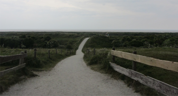
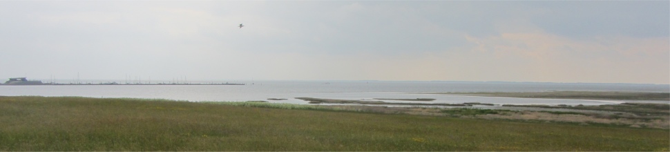 Looking Across Marshland to the Waddenzee from a Dike, Friesland a Smudge on the Horizon, Skies Full of Water. The Small Yacht Harbour is on the Left |
Within 45 minutes we were berthing on a pontoon attached by a narrow causeway to the island. Conveniently, a compound stood by the pontoon, full of hundreds of cycles for hire. We wasted no time in picking up a bike each, and cycled to the only village on the island, Schiermonnikoog, which was established in 1760 after an earlier settlement was engulfed by the sea. We stopped off on the outskirts to inspect rusting relics from World War II on a piece of land. It was a pretty little village, the roads constructed from east to west to avoid wind problems. Apart from the rural quiet here, it is the neatness and the order of the village layout that attract the attention. It had been planned methodically, the village being built in 1720 according to a preconceived plan at the location of the settlement of Oosterburen, to house the inhabitants of Westerburen who saw their village threatened by the sea. Everything was carefully designed, the built-over strips or "streken", a term that still appears in street names like Middenstreek (Middle Strip), Langestreek (Long Strip), Voorstreek (Front Strip) and Nieuwestreek (New Strip), the layout of the lots, the tight building lines and the ample space that had been allocated to public green. All together it gave a very peaceful, even almost heavenly impression, intensified by the almost complete absence of motorized traffic noise.
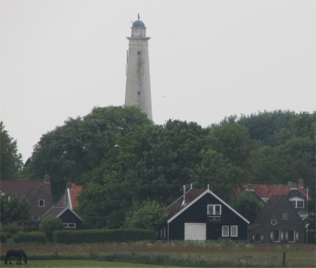 White Lighthouse |
Once replete, we hopped back on our bikes, and headed out to the western side of the island, pondering on the background to the island. The oldest mention of Schiermonnikoog in writing dates from October 1440, in a document written by Philip of Burgundy. At that time the island was part of the property of the Claercamp monastery of Rinsumageest in northern Friesland, near the town of Dokkum. The monks who were living on the island belonged to the order of the Cistercians. They were nicknamed "grey monks", or "schiere monniken" in old Dutch, because of the grey habits that they were wearing. That's where Schiermonnikoog got its name from; the suffix "oog" is an old name for "island" that also occurs elsewhere in the Wadden area such as Lauwersoog. Around 1580 Schiermonnikoog was incorporated in Friesland, in 1638 it was sold as an independent lordship, and from 1892 to 1945 it belonged to the German Counts of Bernstorff-Wehningen. It was acquired by the state in 1945.
 Sandy Path Leading From Red Lighthouse Down Through the Dunes to the Beach by the North Sea. Note the Wide Sandbar Just off the Coast |
As we pedalled in a westerly direction, we took an off road turn, rode up a slight incline and stopped on top of the dike. Stretched out below us was low lying marshland, petering out into the grey expanse of the cold, treacherous Waddezee, licked by flecks of white crests. Friesland stood as a smudge on the horizon. Scudding grey clouds echoed the watery world below.
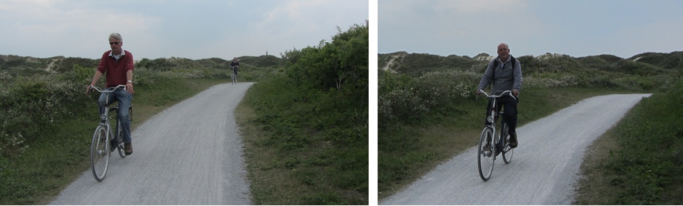 Cycling Among the Dunes, Rex Giving Meryl a Run for Her Money |
This area is dominated by the two lighthouses of Schiermonnikoog, the red-painted outer tower and the white-painted inner tower or South tower, which was situated closer to the village, and the one we were standing next to. I say standing; Rex was nearer a state of collapse. Both towers were built in 1853-1854 with the idea that sailors would be able to use the two lights for defining their exact position at sea. The leading lights would show a safe course of navigation from the North Sea to the Waddenzee, between the sandbanks. However, that trick didn't work anymore after some years as a result of the constantly changing positions of sandbanks and channels. The inner tower became redundant when the outer tower got a revolving light in 1910, and its light was extinguished. However, it was not pulled down but began a new life as a water tower and served this purpose until 1992. Since then several antennas were placed on the former lighthouse and presently its only function is that of a communication tower. Along the entire Dutch coastline, Schiermonnikoog is the only place where you can see two full-size lighthouse towers at such a short distance from each other.
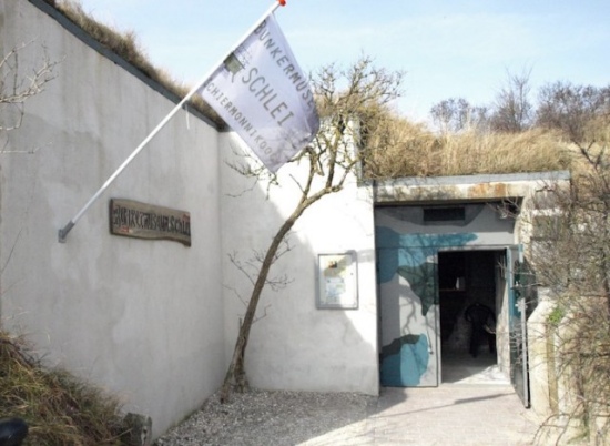 Schlei Bunker Museum |
We proceeded around via the Vuurtorenpad to the red-painted lighthouse on the northern coast of the island, located high on a dune. A path swept down to a hidden beach. A broad sandbank protected the beach from the ravages of the North Sea. In time the sandbank will join up with the beach to form an even wider beach.
We headed back down Vuurtorenpad, crossed the Badweg road leading to the beach, and meandered off through kilometres of dunes and woodland, skirting the only forest to speak of on the island. Originally there were hardly any trees growing here, but at the start of the 20th century, Count Von Bernstorff started planting this pinewood for the commercial production of wood. But as the trees were growing only very slowly due to the hard circumstances, it never produced more than a pleasant enrichment of the island scenery.
|
Triangulation Beacon on Willemsduin |
Near Prins Bernhardweg, a road that that lead to the "bunker village" codenamed Schlei, German for "trench" in World War II, we came across a bunker museum. Now most of the major events in the world did not touch Schiermonnikoog at all. The Eighty Years' War, the French Revolt, the Napoleonic episode, all passed by almost without being noticed by the islanders. But with the World War II, things were different. Shortly after the Dutch surrender in May 1940 a German occupation force arrived on the island that would eventually amount to over 800, doubling the original island population. In the German plans Schiermonnikoog was to become a part of the so-called Atlantic Wall, a coastal defence line that extended from the French/Spanish border to well into northern Norway. To defend the island against the Allies, bunkers were built. Schlei consisted of bunkers, radar installations, anti-aircraft guns and camouflaged barracks.
An important part of the German air defence was a chain of radar stations bearing the code name Wassermann, intended to detect approaching enemy bombers at an early stage, and have them intercepted by fighter aircraft. One of those radar stations was stationed on Schiermonnikoog, and for that purpose a huge bunker was built on the top of the highest dune on the island, which today is still known as "De Wassermann". But when the bunker was completed and the 40m high radar antenna was to be placed it turned out that it didn't fit onto its base. It is assumed that the Dutch subcontractors sabotaged the construction by tampering with the measures. Anyway, the Germans were forced to make do with a much smaller and less sophisticated radar station that was stationed on a nearby dune top.
For the islanders the bunker areas were a strictly prohibited area. The Germans even built a 5.5 km long narrow-gauge railway from the old ferry terminal, now the marina, to the Schlei village, mainly for the transportation of construction materials and supplies. This makes Schiermonnikoog the only one of the Dutch Wadden Islands that ever had a railway on its territory.
The isolated location of Schiermonnikoog caused the war to last longer than elsewhere in the Netherlands. When in April 1945 the province of Groningen was liberated by Canadian forces, a group of 120 SS troops fled to the island, which was still under control of the German garrison. Only on the 7th of May, two days after the general capitulation of all German forces in the Netherlands, the troops on Schiermonnikoog surrendered and it took until June of that year before the last German military actually left and completed the island's liberation.
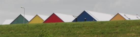 At Last Some Colour, Gable Ends Peering over the Dike at Lauwersoog |
The curator pointed out a small tree next to the bunker entrance. There was a hollow near the base of the tree in which there was a swallow's nest; rather unusual for swallows. As I peered in, four tiny mouths raised skywards and opened widely, chirping their little hearts out.
Leaving the bunker behind us, we cycled through more desolate shrub land towards the eastern extremity. In the distance we could see a long peloton of children on bikes speeding away in a southerly direction. We were to learn they had the right idea. The cycle path stopped abruptly near the triangulation beacon on Willemsduin. Progress beyond this point was only by foot. Around us were all the characteristic features of the other Wadden Islands: beach, dunes, forest, a polder, salt marshes and, of course, the mud flats, as well as diverse flora and fauna, but everything on a smaller scale; a haven of tranquillity.
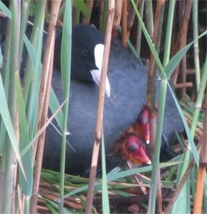 Coot and Two of Her Chicks on the Nest |
We reached the ferry terminal, miserably drenched to the skin and cold. The terminal was totally bereft of humanity. The token acknowledgement to weary travellers was a waiting room containing a drinks dispensing machine. We had a choice: spend two cold hours in abject isolation with a cup of hot chocolate each, or cycle three kilometres to the village, under the constant threat of more rain. At least we were protected from the elements where we were, so we stayed. Gradually other sodden cyclists joined us and soon we were a steaming throng with a smell of stale sweat and damp clothing pervading the small waiting room. Oh what joy!
Our ferry made its long sweep around the channels back to Lauwersoog, and after showers and dry clothing, we were ensconced in the small campsite restaurant heartily enjoying fish and meat. For some reason, Rex and my attempts at ordering food in Dutch to the attractive young waitress were interpreted by Meryl to be flirtatious. As if!
We had fond memories of the island, and we really felt we were on an island due to the isolation. It is not surprising that on 13th May 2006 Schiermonnikoog was chosen from twelve nominations as "the most beautiful place in the Netherlands" in a TV poll that was organized by the NCRV network.