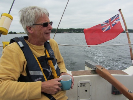
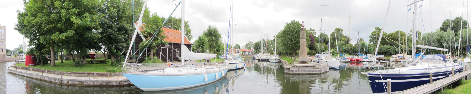
Here, just after the large ring road bridge, we pulled into the pretty, little W.S.V. de Werf marina. No sooner had we motored into this little gem, than we were greeted by two old men who indicated that we head up to one corner. The smaller of the two took our stern line to aid us in tying up alongside an embankment in the compact marina. It later appeared that he kept this area for British boats. Once safely moored, he beckoned that we go down to register our stay. Rex and I muddled through a registration conversation, us interjecting in Dutch, and one of the old men replying in German. "Crumbs, how difficult can this be?" I thought. After our registration had lurched to completion, I pushed my luck and asked about the steam train that ran from Goes (I had read that a small tourist steam train ran for a few kilometres south of the town). I soon learned the Dutch for steam train, but the old man added that it ran every hour to Vlissingen and Amsterdam. There was clearly a loss of communication along the line. We gave up, thanked the man profusely, and returned to the sanity of the boat. An internet check revealed that the train ran only on Sundays to Boersle.
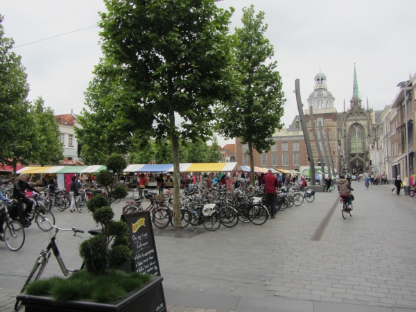
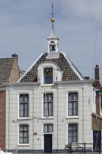
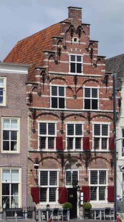
Grote Markt, with the Stadhuis and Grote Kerk in the Background
|
Provisions were required, and soon we found ourselves walking by the Binnenhaven on the way to the Grote Markt. The market was large, hugged in on all sides by cafes, bars and restaurants, some decked out in orange bunting, obviously passionate about the Dutch football team. An array of multi-coloured stalls peppered the square, selling clothing only. The south end of the square was dominated by the Stadhuis and Grote Kerk of Maria Magdelenakerk behind.
Rex was tickled pink when he witnessed an old lady cycle right through the supermarket from one end to the other. Only he batted an eyelid. Food supplies purchased, followed by coffee at one of the busy cafes in the square, we carried our provisions back to the boat, and by 6pm were heading back to the square for a meal with the ulterior motive of watching England play Uruguay in the World Cup.
It soon became apparent once we were ensconced inside the Jersy Restaurant in front of a large screen that I had suffered a serious senior moment. The match was due to kick off at 8pm UK time, and instead of adding an hour on to compensate for Dutch time, I had subtracted an hour. Take me out and shoot me!
So, there we were over 2.5 hours before the game kicked off. After some ribbing, we enjoyed a meal and a drink. Meryl was feeling tired and had no desire to hang around for the football, so we walked her back to
Duonita, and then headed back to the same venue to watch the match.
Inside, only four pairs of eyes took interest in the game: two British, one German and one Dutch. I won't dwell on the game, we lost and were out of the World Cup.
To add to our deflation, on our tramp back to the boat poor Rex was starting to suffer from stomach cramps. Poor fellow.
20th June
Rex had suffered badly through the night and was feeling pretty rough in the morning. Normally he is a bright and perky chap first thing, first thing being around 6am, but today he was clearly jaded. Copious amounts of medication had been consumed, and now he had just noticed that the instructions that came with the medication advised that he should follow a strict dietary regime for as long as he took the medicine. Those were the last words of wisdom he wanted to hear, and he moaned that he would be better off in a health clinic.
As we sat out in the cockpit watching the racing clouds tease us with an occasional glimpse of blue, a German woman in her late thirties approached us. She and her family were trying to get to Dover, and sought advice on how to make the trip from Vlissingen. It rapidly became apparent that they did not want to tackle long stages, so Rex quickly advised a non-direct approach based on tidal flows. His recommended route was Vlissingen > Ostend > Dunkirk > Dover, a series of easy stages that could take advantage of the tides. The lady seemed happy with the information and off she went to report back to her other half. Rex chewed his upper lip a little before pronouncing, "I wonder if they are using a world atlas as their navigational aid."
My mind was taken back to a recent meeting Dan and I had with a couple who were sitting on a nearby restaurant table in Ipswich. The portly chap of mature years casually mentioned, "I think I'll buy a boat so that we can go sailing around the Mediterranean." "Hmm.... , I don't envy you crossing the Bay of Biscay. Have you sailed across it before?" I asked. "No, it shouldn't be difficult," he replied. My curiosity got the better of me, "Have you done much sailing across the North Sea?" I asked. "I think you've met your match, dear," piped up his wife to him, with a mischievous smile on her lips. He looked across to her, and then at me with a slightly worried expression, "No, I've never sailed before." I let it go, hoping that my probing had made him think twice. I recounted the story to Rex, who related how lots of folk have taken on board challenging sailing trips with no experience whatsoever. Some do pay the penalty, but surprisingly many muddle through and learn from their mistakes.
With Rex wishing to be close proximity of a toilet for the next few hours, and Meryl happy to read a book and keep her hubby company, I set off to the VVV (Tourist Information Centre) to check out on points of interest in the area. The lady at the desk was most helpful: no, the TV/radio tower was not open to the public, and the steam train only operated on Sundays until July, when it opened every day. However this Saturday was a special day, being opened primarily for children. Ah, a "Thomas the Tank Engine" day I thought. She kindly gave me a leaflet covering a self-guided walk around the town, all in Dutch of course.
Off I set, leaflet in hand. So how did this town come about? In the 10th century, on the edge of a river, de Korte Gos (the Short Gos), a small settlement was created; Goes. The village grew rapidly and in the early 12th century it boasted a market square and a church devoted to Maria. In the 13th century Goes grew into a port town and the town acquired more and more rights. City rights were granted in 1405, and Count William VI gave the town permission to administer justice in serious crimes, a process that sealed the shift from village to town. In 1417 Countess Jacoba of Bavaria gave the town permission to build walls and gates around the town. Seafaring, cloth making and especially the production of salt were principal means of livelihood in the 15th century. During this period the town continued to grow despite the uncertain political situation, wars, floods and crop failures. However, the connection to the sea gradually degraded, and during the 16th century Goes declined. A large fire in 1544 destroyed a part of the city with a quarter of the wooden houses being burnt down. The town's population at that time was around 1,750.
The Eighty Years' War (1568-1648) in the Low Countries was characterised by sieges of cities and forts, field battles being of secondary importance. It was during this period, in autumn 1572, that Dutch forces together with the support of English troops besieged Goes, which at that time was part of the Spanish Netherlands. The siege was relieved in October 1572 by Spanish Tercios (Spanish Third), a Spanish military unit during the period of dominance of Habsburg Spain in Europe and the Renaissance era. The tercio was an infantry formation made up of pikemen, swordsmen and musketeers in a mutually supportive formation, and the Spanish Tercios were the first modern European army, understood as an army of professional volunteers. In 1577, Prince Maurits of Nassau drove out the Spanish soldiers who occupied Goes. He then had built a defence wall around Goes, parts of which were still visible. In the subsequent centuries, Goes maintained its importance as an agricultural centre, but industrialisation never really took off.
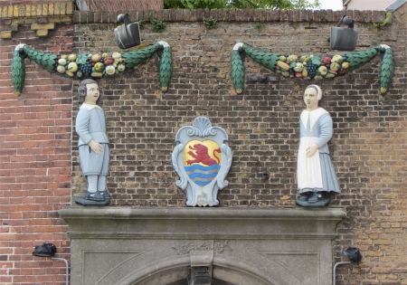
Above the Arch Leading to the Weeshuisplein
|
The streets I began walking around were hardly different from those in the 16th century. However, the buildings and houses in the course of the centuries changed regularly. The self-guided walk would take me through the old streets and squares of the time.
Above the Door into the Manhuis
|
The VVV itself was located in an historic building on Singelstraat, the Weeshuis (orphanage). This 15th century building was part of the housing of the Black Sisters, an order of nuns. The sisters devoted themselves to nursing. In 1627 the monastery was in use as an orphanage. Between 1620 and 1795 the former convent chapel served as a Walloon church, offering shelter to the soldiers. From 1821 until shortly before World War II, the chapel served as an orphan's school. In 1970, the Historical Museum Bevelanden was established here. Behind the Weeshuis lay a beautiful small courtyard, the Weeshuisplein, reached by passing under an arch next to Weeshuis.
Grote Kerk of Maria Magdelenakerk
|
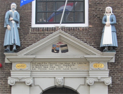
The Manhuiscomplex stood next to the Weeshuis. For a long time the Manhuis was established in an annex to the monastery of the Black Sisters. In 1655 they founded a new building and in 1689 provided a private entrance to the new Manhuis, a gate decorated with two stone statues. Between 1741 and 1787 the Manhuis acted as a host, a military hospital and barracks. It continued until 1962 as an old "singing" house. In recent times, the owners, the municipality of Goes, have been trying to get rid of it. The Dutch too feel the economic squeeze.
I walked across a pedestrianised area, on which several centuries earlier stood the Klokhuis. This was a tower built in 1384, paid for by tax on beer, wine and beef cattle. Crikey, just those taxes to worry about; how times have changed. The stone tower with a wooden roof served to give: church ceremonies, commencement and conclusion of the market, opening and closing of the gates in case of fire and danger. This church building itself was demolished in 1661.
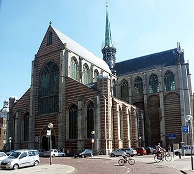
On the eastern side of the pedestrianised area stood the Grote Kerk of Maria Magdelenakerk, a dominant, colossal building in the heart of the town. The history of this building goes back to the 12th century when a small Catholic church room was built at this location. This room was expanded to the East several times. In 1455 a major reconstruction and extensions started, that were finalised in 1520. In 1578 the building was taken over by Reformed church. It was rebuilt, mainly in stone, after 1618, when a fire was started by the carelessness of a slater. The tower was erected during the rebuilding of the church. Sadly the main church was not open to the public today. Peering through the huge glass doorway I could detect all the paraphernalia of refurbishment. Perhaps I was a month early.
Stadhuis
|
A narrow street brought me into the Grote Markt. In 1389, the Grote Markt was called the Korenmarkt (corn market). In 1417 the inhabitants of the city were granted permission to hold the Goes fair or carnival during August, lasting eight days. At the fair mainly cereals and pulses were traded. There was a lot of fun. From 1684 the market operated every Tuesday. The market was divided up into smaller markets: grain and seed market, cloth market, basket makers market, etc. Visions of Breughel paintings conjured up in my mind.
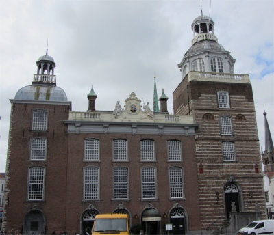
Sandwiched between the Grote Markt and Grote Kerk stood the Stadhuis (Town Hall). Late Gothic and Rococo in style, the oldest part was the right tower (1389), which served as a prison, the "vanghuus". In addition, there was a market hall where the weighing-balance stood. Above this stood a hall, furnished like a tribunal where justice was meted out, and where the city council met. Behind the market hall were the meat market and stalls for rent. An orphan room and a city messenger house were built in 1463. The upper floor of the town hall was still used for receptions and weddings.
't Huys van Borsele
|
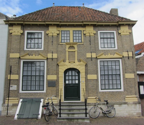
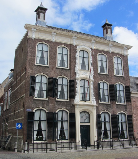
On one side of the market square stood 't Huys van Borsele. This building, whose facade dates from 1675, is named after Frank Borsele (1386-1470). This Zeeland nobleman was from Zeeland, and in 1432 became the fourth husband of Jacoba of Bavaria, until she died in 1436. The house was a residence until 1997.
I made a slight detour down a street named the Oude Vismarkt (old fish market). Here, the Old Fish Market could be found in medieval times. There were a number of banks that fishmongers could rent per year, upon which they sold their wares. At the beginning of the 17th century, the fish market was moved to the Turfkade. The only thing of note on the "bank" now was a small dance theatre.
I carried on down this street, passing the Poort Gasthuisstraat, once part of the convent of the Agnientenzusters and a hospital in 1450. It continued to house a hospital up to 1969. I was pleasantly surprised when I popped out of Gasthuisstraat onto the Oostwal, and I stood for a long while smiling at nine geese overseeing three small goslings pecking amongst the grass by a pretty lake.
I retraced my steps up through the Oude Vismarkt and turned up Sint Jacobstraat. The gate of the house number 9 was a test piece of a journeyman mason. This area was once the skipper's quarters, and the street is named after St. Jacob's house at number 17. St. Jacob was the patron saint of boatmen.
Just off Sint Jacobstraat lay a small square in which the oldest reference to the Bocht van Guinea (Bight of Guinea) could be found, dating from 1762. Lower and Upper Guinea were conquered by the Dutch at the beginning of the 17th century. These lands, also known as the Gold Coast, were located on the west coast of Africa. Along the coast of the former colonies are numerous bays and inlets, which can also be called curves or bights. On the Bight of Guinea, Fort St. George d'Elmina was built. This Portuguese fort was captured by the Dutch in 1637, and was presumably remembered in many street and square names. This had been a poor neighbourhood, the original houses long gone. Blue stones in the pavement indicated the position of the former walls, each containing one large and one small bend. A well once stood at the entrance to the square.
St. Maartenbrug
|
I carried on up to the end of Sint Jacobstraat, and discovered a fascinating little business at the top of it. Peering through the windows, it appeared to be premises where tiles were painted by hand, many with typically Dutch motifs such as windmills and old sailing boats. The artisan was obviously a skilled draughtsman, and the tiles spread about on tables contained mostly delicate blues lines on a white background. Paint encrusted cans stood on a table, packed with delicate sable riggers, next to small pots of paint. Sadly the place was deserted today; I would have loved to enter and chat with the artisan.
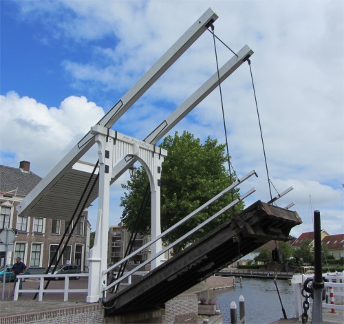
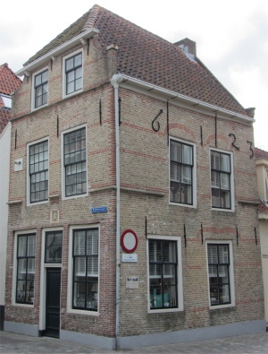
St. Maarten or Dark Gate stood on the junction of Goeskade and Kleine Kade (Goes and Little Quays) until 1853. On the other side of the basin was the Oostere Poort (East Gate). Around 1970 talks took place concerned with the filling in of the basin for a car park. Common-sense prevailed, and instead St. Maartenbrug was erected, allowing water craft to enter the basin for mooring purposes. I watched the harbour master operate this little gem. After manually lowering the barriers to halt pedestrians and cyclists, he rotated a wheel to unlock the bridge, and then strolled across the bridge and casually pulled a chain which opened the bridge, all done by hand. I noticed that the bridge was carefully counterbalanced by a plastic container tied below the bridge with just enough water inside it to maintain the perfect balance. Closing the bridge was achieved with what seemed like a flick of the wrist to lift up the counterbalance. Ingenious.
Houtloodsen
|
Just up from St. Maartenbrug on the west side of Joachimikade, stood some wooden sheds, Houtloodsen, built on a farm around 1820. During 1890-1900, the barns and houses were used for rope manufacturing and as warehouses. At the beginning of the 80s, the activity in the timber sheds ceased.
Huize Hoope
|
Crossing over St. Maartenbrug onto Goeskade, I stopped to have a look at Huize Hoope (House Hoope), dating from 1651. Huize Hoope had been used from 1868 to 1939 as a bridge guard house. During WWII the basement served as an air raid shelter. Now the Goes Monuments Foundation is based here, which manages a large number of listed buildings.
The door to the building next door was open and I could see lots of paintings hung up as if a gallery had been set up on the ground floor. Art exhibitions are always a magnet to me, and I was drawn in by an invisible force. "Would you mind if I look around the paintings?" I asked a woman. "Sure, no problem," she replied. The paintings were very colourful, but lacked structure and composition. It took me a short while to twig that they were special. I noticed several young folk around who had learning difficulties, busying themselves packing catalogues into envelopes, sealing cards into gift packs etc. This was obviously a centre for people with learning difficulties, and the paintings were the work of these lads and lasses. Memories flooded back of all the years I spent doing voluntary work with people with learning difficulties, and I was gladdened to see these young folk happy in this most pleasant of environments. Long may the good work continue.
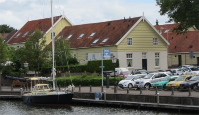
I walked back down Goeskade into Kleine Kade (Little Quay), formerly Speudijck. For some reason which escapes me, from 1400 Speudijck went by the name Kleine Kade, the latter name being officially recognised in 1850. Numerous boats were moored along the quay, very handy for the town, but not as attractive as our cosy little marina run by the old men.
Kleine Kade
|
Soepuus
|
Soepuus Tower
|
Lodewijk XIV Style Building
|
Towards the bottom of this Binnenhaven, I came across a striking white building with a clock and tower containing a single bell, the Soepuus. In 1484 a tidal water mill was built here. This was in use until the 18th century. The tower came from the St. Maarten or Donkerer Gate, the clock was made in 1624. The property was known as "Soepuus" because the commission of food distribution handed out winter soup to the poor from this building during the 19th century.
A couple of doors down from the Soepuus stood a grand building in the Lodewijk XIV style, topped by two towers. In actual fact it was built around 1765 by joining two premises. The house on the left is from the 16th century. The front is from the former hotel, "The Korenbeurs".
Visperk
|
At the head of the basin lay the Turfkade (Peat Quay). For centuries peat was brought ashore here, to be used for heating and as fuel for the salt works. A stone had been set in the pavement to mark where the peat was weighed.
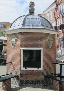
The small open area on the Turfkade first bore the name "New Fish Market", and later became known as the Visperk. The small octagonal building replaced an earlier one in 1647 when the fish stalls were no longer required. It was used as a place where fish was sorted and distributed to the fish market.
Gotische Huis
|
Overlooking the Turfkade was the magnificent Gotische Huis (Gothic House). This property was built in 1555 and was also known as the Karel V house. Karel V gave tax exemption allowing the reconstruction of the building after the fire of 1554. Above the door is the coat of arms of Karel V. The building housed the museum of Goes from 1930 to 1970. Since 1992 it has been a restaurant.
Heading back along the other side of the basin, the south side of the quay, I pondered on why it had ever been called the "South Side of the Quay". For centuries it had been the landing place for beer, and in 1929 the name was officially changed to Bierkade (Beer Quay).
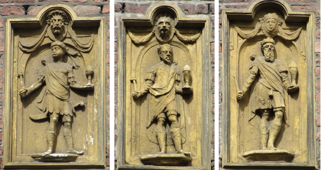
We Three Kings: Caspar, Balthazar and Melchoir
|
On the corner of Bierkade stood the Drie Koningen Huis (Three Kings House). This property was built in 1555 as a grain storehouse. The three bass reliefs on the side of the building were Caspar, Balthazar and Melchoir.
Pomp Beestenmarkt
|
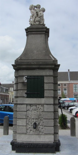
Heading off in a westerly direction, I found myself entering a large square, the Beestenmarkt (Cattle Market). One third of the Beestenmarkt was occupied by the monastery of the Brothers of the Cross from 1429 to 1554. Sadly, the 1554 town fire left the monastery severely damaged, and in 1578, the brothers left the remains of their monastery. From 1580, the open space left behind was put to use as the "New Beestenmarkt". Now, a six-day cattle fair is held here annually.
In the centre of the square stood the Pomp Beestenmarkt (Cattle Market Pump). Dating from 1774, this pump originally stood on the Grote Markt. In 1853 it was moved to the Beestenmarkt to replace the wooden pump. It wasn't just cattle that enjoyed the water flowing from this pump, it was also the supply for Goes residents.
St. Jacobusschool
|
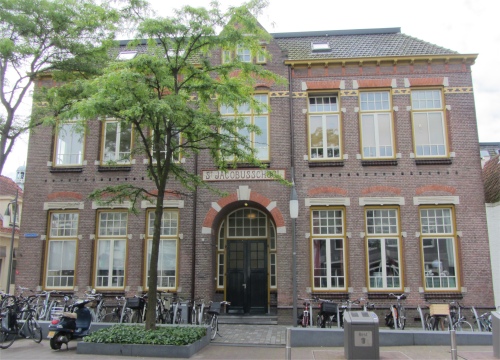
A short distance from the Beestenmarkt was the Vlasmarkt (Flax Market). What had been the Beestenmarkt until its move around the corner, became the Vlasmarkt in 1580. It was then called the Oude Beestenmarkt (Old Cattle Market). A noble looking building dominated this square. In the 16th century, a large mansion stood here, 't Huys van Lodijk. In 1881 it was bought by the Roman Catholic Church, and converted in 1905 into a convent for school girls. This school was demolished in 1913 and replaced by the new St. Jacobusschool. It has served as a residential property since 1986.
Den Bastiaen
|
An elegant building stood just past St. Jacobusschool on the corner of Rijfelstraat, "Den Bastiaen". From 1623 to 1647 this house served as a home at the back of the tavern "Groote Soutkeete" which stood on the Grote Markt, the owner of both properties was the Goes man, Cornelis Jacobsz. After he won the annual festival longbow shoot on three consecutive occasions he was claimed "emperor" of the militia, and became St. Sebastiaen. The plaque above the door depicts St. Sebastiaen, patron of the guild of longbow shooters.
The self-guided walk leaflet had served me well, and in a whistle-stop 90 minute walk, had achieved what it set out to do, guide me around the 16th century streets of Goes. I returned to
Duonita to discover that Rex was now much improved. Indeed he felt ready to tackle the town, so I took the couple around the route I had taken, trying my best to show them what I had learned. When we arrived at the Bierkade, Rex and I looked down into the basin at the yachts and saw the favourite pastime of the Dutch in operation, cleaning, a boat in this case. What made us smile in bewilderment was the fact that a rather obese chap was casually leaning against the wheelhouse, hosepipe in hand, while his poor wife was busy scrubbing away at wherever he directed the water flow. Why she didn't wrap the hosepipe around his neck I'll never know. Rex chuckled; he was on the mend. Later, he indulged in a little retail therapy, which improved him more, but not his wallet.
The sun shone down on us as we returned to the marina, and in the evening we tucked in to a tasty pasta dish that Meryl had prepared, rounding off the day nicely.