Soon we were on a train racing through the green, lush land of the Biesbosch by the path we had cycled along two days earlier. We flew over the Beneden Merwede and in no time at all we were arriving in Gorinchem, our first port of call in the Fortified Triangle, and also our first visit to the Dutch Waterline.
Great swathes of the Netherlands lie below sea level, and the Dutch have long struggled with the water. However, water hasn't always been the only enemy of the country. In times of war, water became a welcome ally and the nation's best line of defence. In the past, the Dutch caused intentional inundation using the Netherlands' biggest secret weapon: the Dutch Waterline.
It was during the early phases of the Eighty Years' War of Independence against Spain (1568-1648), when the Dutch started experimenting with ways of using water as a line of defence. The first successful strategic flooding took place in 1574 when dykes were cut during the siege of Leiden, flooding the land around the city. In the latter half of the war, when the province of Holland had been freed of Spanish troops, Maurice of Nassau planned to defend it with the Holland Water Defence Line, which was a continuous strip of low-lying land, stretching from the Zuider Zee (now the Ijsselmeer) to the river Merwede, protected by fortresses. The main objective of the line was to defend the west of the country, and the powerful province of Holland in particular.
In 1629, Prince Frederick Henry started the execution of the plan. Sluices were constructed in dykes and forts and fortified towns were created at strategic points along the line, with guns covering the dykes that traversed the water line. The water level in the flooded areas was carefully maintained at a level deep enough to make an advance on foot precarious and shallow enough to rule out effective use of boats (other than the flat bottomed gun barges used by the Dutch defenders). Authorities would evacuate the people living in this strip and cut the dykes to inundate the land, creating a physical obstacle to invaders. In wintertime the water level could be manipulated to weaken the ice covering. This Old Dutch Waterline proved itself in 1672 during the Franco-Dutch War (or Third Anglo-Dutch War), when it halted the armies of Louis XIV from conquering the Dutch Republic. The Republic of the Seven United Provinces of the Netherlands then had a weak defence system, and as the French reached Utrecht, a waterline was quickly improvised in time.
In 1794-1795 the revolutionary French armies only overcame the obstacle posed by the Old Dutch Water Line due to the heavy frost that had frozen solid the flooded areas. It was during the French period, (1796-1812) that the Old Dutch Waterline proved itself fallible, and a decision was taken by government to implement considerable alterations and expand the water line. After the final defeat of Napoleon in 1815 at the Battle of Waterloo, the United Kingdom of the Netherlands was formed. In 1815, on the advice of Cornelis Krayenhoff, Inspector General of Fortifications, King William I decided that Utrecht should be included in the waterline. The Utrecht Waterline was built and this later became the New Dutch Waterline. Between 1816 and 1824, many forts were built in order to extend the waterline out towards the east. Work nevertheless continued on the Old Dutch Waterline until it was properly completed and it served temporarily as a reserve line. In 1874, the Vestingwet (Fortification Act) determined that the New Dutch Waterline would become part of the country's central defence system. The New Dutch Waterline was also based on the concepts of water management and flooding. These inundations were now more extensive and easier to manage. Five-kilometre stretches of polder land could now be flooded along a length of 85 km from Muiden (on the Zuider Zee) to Werkendam (near the north-east tip of the Biesbosch).
In contrast to the Old Dutch Waterline, the New Dutch Waterline had never been operational. There were, however, three moments in history when the line was put on standby: during the Franco-German War (1870), during the First World War and during the mobilisation of the Dutch army in 1939. At the advent of World War II, most of the earth and brick fortifications in the New Dutch Waterline were too vulnerable to modern artillery and bombs to withstand a protracted siege. To remedy this large number of pillboxes were added. However, the Dutch had decided to use a more eastern main defence line, the Grebbe Line, and reserved a secondary role for the New Dutch Waterline. When the Grebbe Line was broken on May 13th, the field army was withdrawn to the New Dutch Waterline. However, modern tactics could circumvent fixed defence lines. While the Dutch army was fighting a fixed battle at the Grebbe Line, German airborne troops simply bypassed the New Dutch Waterline and captured the southern approaches into the heart of "Fortress Holland" by surprise - the key points being the bridges at Moerdijk, Dordrecht and Rotterdam. When resistance did not cease, the Germans forced the Dutch into surrender by aerial bombing of Rotterdam, and threatening the same for Utrecht and Amsterdam. Therefore, during the Battle of the Netherlands in May 1940 there was no fighting at the New Dutch Waterline itself. After World War II, the Dutch government redesigned the idea of a waterline to counter a possible Soviet invasion. This third version of the Water Line was erected more to the east at the Ijssel (the Ijssel Line) and in Gelderland. In case of an invasion, the water of the Rhine and the Waal were set to divert into the Ijssel, flooding the river and bordering lands. The plan was never tested, and it was dismantled by the Dutch government in 1963.
The foot of the New Dutch Waterline was in a unique position, namely the confluence of the famous Dutch rivers the Maas and the Waal, which converge and become the Merwede. It was also at this point where the three provinces: North Brabant, South Holland and Gelderland met. These rivers are major, the Waal coming down through Germany as the Rhine, and the Maas leaving Belgium where it is better known as the Meuse. Obviously they would be an easy route for invaders to take, and it made sense to establish fortresses at this important crossroads where access to inland waterways could be controlled. Three medieval fortresses and a fort were constructed on this southern outpost of the New Dutch Waterline: Gorinchem, Woudrichem, Slot Loevestein and Fort Vuren, which together formed the "de Vestingdriehoek" or the Fortified Triangle. This triangle is one of the Netherlands' most impressive defensive strongholds of that era.
Gorinchem
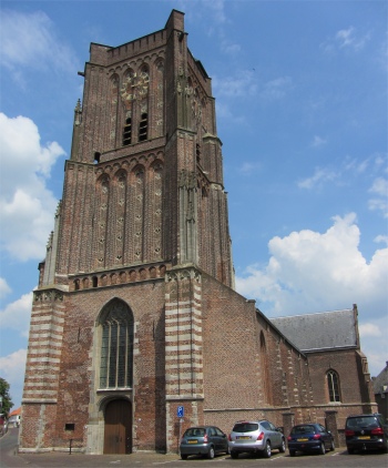
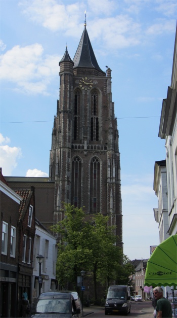 St. John's Tower - Gorinchem Grote Kerk |
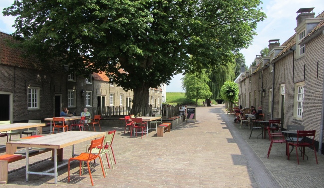
We found ourselves walking down an olde-worlde but very busy shopping thoroughfare. The city's history was tangible and visible, and the street pattern created in the 15th and 16th centuries was still intact. Spotting a tall tower, a quick turn right brought us down to the Grote Kerk, the iconic and most distinctive building of the city, which was of course closed.
At the place where the present church stood there was a Gothic hall church, St. Martin's, which was inaugurated on April 12th, 1263. Around 1570, it was known as the St Martin "Church" and later in the 16th century when there was a small chapel in the Arkelstraat, it was named the Grote Kerk. Since 1517, the 67 meter high Gothic Grand Tower, also known as St. John's Tower, defined the image of Gorinchem. During construction, which lasted for decades, the lower section prolapsed, and the following two sections were then mounted vertically upon it. Thus, like many other Dutch towers, it had a noticeable tilt, and was over 1.5 meters off plumb. In the winter of 1813-1814, with the French in town, and the Russians and Prussians on the Merwede, the church was heavily shelled. On August 31st, 1844, the church had to be closed by order of the Mayor and Aldermen, and the church was demolished. Architect I. Warnsinck from Amsterdam was commissioned to design a new church building, a task which he performed with his student Abraham Nicolaas Godefroy, which had to attach to the tilting tower. The neo-classical new church building was constructed out of red brick, interspersed with yellow ornamental stones on a stone plinth under slate covered saddle and pent roofs.
Behind the Grote Kerk, in the Groenmarkt, presided a pretty, ivy-clad building, the former town hall dating from 1860. Since 1995 the museum and VVV had been housed in this grand building.
We took time out for a coffee in the sunshine in the Groenmarkt by the museum, and pondered on the turbulent history of this fortified city. It was assumed that Gorinchem was founded circa the year 1000 by fishermen and farmers on the raised land near the mouth of the river Linge at the Merwede. "Goriks Heem" was first mentioned in a document from 1224, in which Floris IV granted people from Gorinchem exemption of toll payments throughout Holland. Somewhere between 1247 and 1267, Gorinchem became property of the Lords of Arkel. At the end of the 13th century earthen mounts reinforced with palisades were built around the settlement to protect it from domination by the neighbouring counties of Holland and Gelre. Half a century later real city walls were built complete with 7 gates and 23 watchtowers. Otto van Arkel granted it city rights on 11th November 1322.
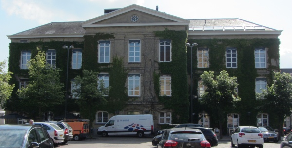 Gorinchem Museum |
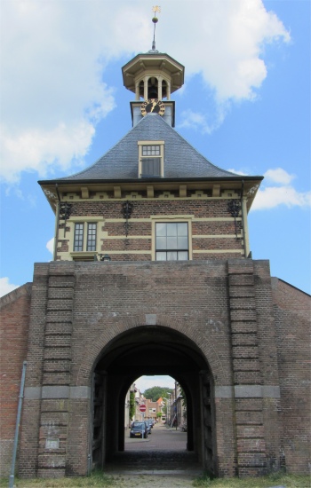
In the 16th century the city walls were so deteriorated that they were replaced with new fortifications and eleven bastions, which still exist almost completely intact. The new walls were rounded off in 1609 and were placed farther from the town centre, making the city twice as large. In 1673 Gorinchem became part of the Old Dutch Waterline. The city walls had four city gates: the Arkel Gate in the north, the Dalem Gate in the east, the Water Gate in the south (where the ferry to Woudrichem departs), and the Kansel Gate in the west. Of these four gates only the Dalem Gate remained, the others were removed in the 19th century to make way for vehicular traffic.
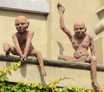 Museum Characters |
We mustn't forget Gorinchem's famous son, though he had been almost forgotten by the city. Hendrick Hamel (1630-1692) was the first Westerner to write and experience first-hand in the Joseon Dynasty era in Korea (1666). He later wrote "Hamel's Journal and a Description of the Kingdom of Korea, 1653-1666", published after his return to the Netherlands.
Hendrick Hamel was born and died in Gorinchem. He was a bookkeeper with the Dutch East India Company (the VOC). In 1653, while heading for Japan on the ship "De Sperwer" (the Sparrowhawk), he was shipwrecked on Jeju Island off the southern coast of Korea along with thirty-five of his crewmates. 36 of the 64 members of the crew survived the shipwreck, and the men were promptly taken into custody and sent to Seoul (where the king was Hyojong of Joseon, who ruled from 1649 to 1659). They were forbidden to leave the country, but they were given some freedom to move and mix with the different classes of Korean society. In March 1656, the men were taken to a town with a fortress, Gangjin. They stayed there for seven years. In 1663 the remaining 22 survivors (because of a famine) were spread across three cities. Hamel ended up at Yeosu, from where he and seven others escaped three years later. After a total of thirteen years, Hamel and seven of his crewmates managed to escape to Japan, and from there to the Netherlands. In 1666, three different publishers published his report, describing their improbable adventure and giving the first detailed and accurate description of Korea to Europe. Since 1998, Gorinchem has been twinned with Gangjin in South Korea.
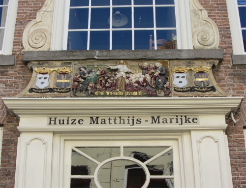 Huize Matthijs-Marijke |
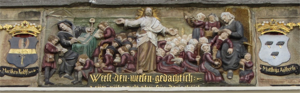 Bass Relief on Huize Matthijs-Marijke |
 Alpha-Lynx Internet Services Premises |
At the bottom of Schuttersgracht, we climbed up onto the ramparts that surrounded the city, and proceeded to walk around the ramparts in a clockwise direction. Immediately below us was the Passantenhaven, brimming with yachts. This stretch of the ramparts was popular with dog walkers; it paid to watch one's step. The old bastions were clear to be seen, the second of which was crowned with gun emplacements from centuries ago. If only those canons could talk, what a tale they could tell. We continued on our way, passing the road along which we entered the city, blocks of flats fronted by weed choked ditches, and passed more marinas and the Nooit Volmaakt (Never Perfect) windmill on the Bagijenwal bastion that lay beside the Linge river. This river passed straight through the middle of the city. Numerous houseboats were strewn along the embankment here, some ugly sheds, others of smart construction complete with gardens and jetty. To the east of the city, the "moat" became lakes hidden by blankets of lilies, and bordered by allotments hidden in leafy shades.
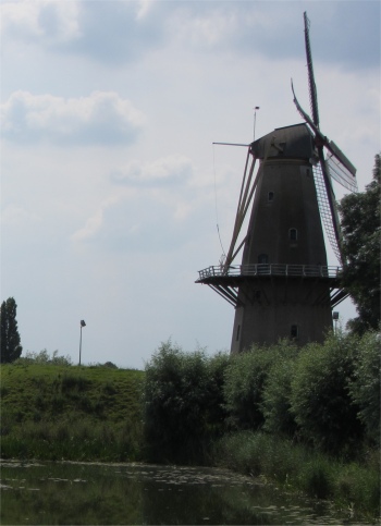
As we rounded the south-eastern corner of the ramparts, along the Dalemwal, we were pleasantly surprised to have De Hoop (The Hope) windmill appear in our view. This flour mill had been standing on the ramparts of the Boven Merwede since 1764. It took more than a hundred years before the mill was given the name "De Hoop" by the then new owner Anthony Jacobus van de Water in 1879. In 1900 a gas engine was installed in the mill to enable grinding to take place with no wind. However, by the 30s, the economics of the mill was not paying off, and it became neglected. Half-hearted attempts were made to repair the mill since then, and it was finally during the 90s that a major refurbishment was carried out, resulting in the mill being officially inaugurated in 1995.
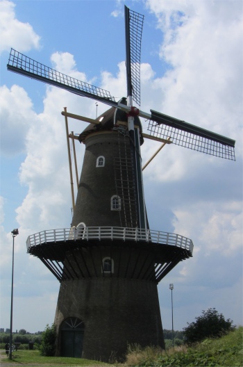 De Hoop |
 Dalempoort |
Everywhere there was much evidence of restoration work, which had been painstakingly carried out tastefully and skilfully using traditional materials. It was in a beautiful condition, the best example of a working mill I had seen in a long time. The man had done his best to explain it all, and we thanked him profusely as we left, leaving a suitable donation in the box. I worked out the mill wasn't officially open today but he had taken the time to show us his pride and joy. It would be working every day during the summer, grinding corn for all the holiday makers to see.
Carrying on along the Dalemwal, within a very short distance we came across the Dalempoort. The Dalempoort dated from 1597, and was the only remaining gate of the original four that were fortified after the improvement of the wall, which was completed in 1609, and this charming gateway was enlarged in 1770. The other three were the Kansal (Pulpit) Gate, the Arkel Gate and the Water Gate; all three were demolished to make way for the growing traffic problem. The building was a rectangular structure, covered by a pavilion roof with cupola tower (c.1600) with a clock. The doorway was arched by a barrel vault and a ribbed cross vault.
Walking along the Altenwal past the last bastion, we came to the lock that allowed watercraft access between the Linge river and the Boven Merwede. When an army of teenage school children had finally crossed the lock, and they weren't in any particular hurry, we made our way around to the ferry terminal to catch a boat across the Boven Merwede to Woudrichem in the province of North Brabant.
Woudrichem
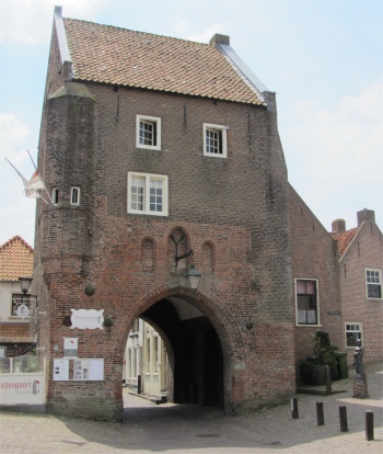 Gevangenpoort |
Once inside the city walls, we realised how small the place was compared to Gorinchem. However, what it lacked in size, it more than made up for in beauty. This beautifully preserved medieval city was practically in its original state. Thick earthen ramparts still surrounded the town, and within, old brick houses and cobblestone lanes gave Woudrichem that medieval feel. Indeed, if the cars were removed from the streets it would be difficult to tell which century it was.
 Martinuskerk |
Just past the church was the Cultuur en Visserijmuseum (Fisheries and Cultural Historical Museum). We entered into another world which covered the centuries-long relationship with the river and the salmon fishery. The attendant was not fluent in English, but we learned that at one time salmon and eels used to travel all the way from the sea up these rivers to their spawning grounds in Switzerland. This created a fishing industry, with a local fleet of salmon scows, blunt front-ended boats with tarpaulins draped over the front to create a sort of tent for a sleeping compartment. Today, hardly any salmon or eels pass up the river due to pollution.
For centuries the inhabitants of Woudrichem were entitled to fish on large stretches of the Maas and the Merwede. This was a special privilege granted in 1362. When, in 1877, Woudrichem's municipal council interfered with this centuries-old entitlement, the whole town rose up in a "Fishing Revolt", organised by hard-pressed fishermen who, with their large families, faced an uncertain livelihood. The local constabulary and infantry units from Loevestein and Gorinchem were called in to quell the uprising.
In recent years, Woudrichem's historic harbour was given back its original 1650s look, through a very unique restoration project. It had been designated a National Monument, and it was only intended for historic ships like clipper barges, Dutch Stijlstevens and Frisian Maatkasten. In addition to the river Merwede harbour, Woudrichem had two picturesque, yet comfortable marinas on the Maas. We spotted a row of salmon scows on one.
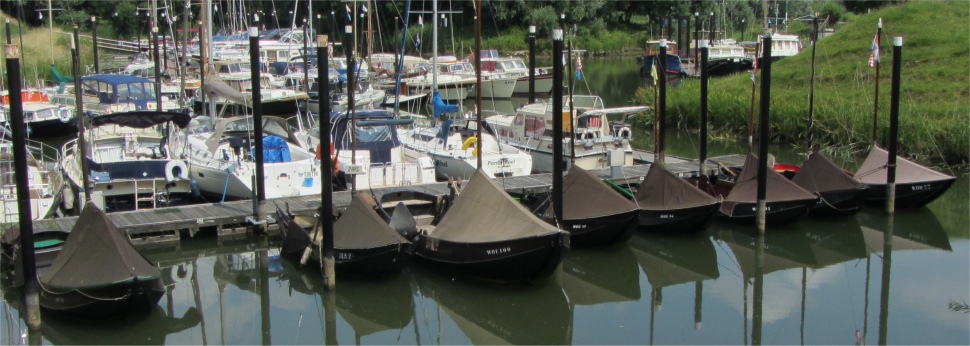 Salmon Scows |
 Nooit Gedagt |
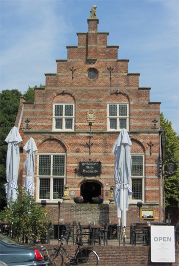 Oude Raedthuys |
The Watergeuzen took the city again after the Spaniards left, but eventually the now heavily devastated Woudrichem was taken back by the State troops. In 1577, William of Orange requested the States of Holland to build a fortress in Woudrichem. He wanted cities, which were located opposite each other on the major rivers, to be strengthened in order to create major obstacles against the Spaniards, and to keep the waterways free for the transport of their own supplies and weaponry. Woudrichem and Gorinchem were both featured as part of his plan. The States of Holland agreed this in 1583. Woudrichem now began its second life. A military garrison was established in the city, and fortifications were constructed in accordance with the old Dutch fortification system. Together with its twin, Gorinchem across the Merwede, Woudrichem firmly anchored the southern limit of the Old Dutch Waterline and succeeded in halting the armies of Louis XIV in 1672. During the winter of 1813/1814, French troops tried to survive in Gorinchem. After the defeat of Napoleon at Waterloo, Prussian troops, encamped in Woudrichem, set about expelling the French. They blasted Gorinchem with six cannons installed on the ramparts, the terrible noise lasting for weeks. Sadly, a large part of the Woudrichem archive was lost at that time; it was used as fuel.
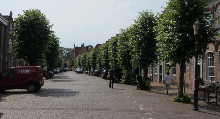 A Neat and Clean Cobbled Street in Woudrichem |
Despite all the tales it could tell, surprisingly the one thing that seemed to instil pride in the city in 1937 was the fact that it had made the news - the city lies exactly on the line of longitude five degrees east. Hmmm...... how many folk in Greenwich regularly perform cartwheels up the street?
We headed along the Rijkswal to pick up the small ferry across the Afgedamde Maas to Loevestein in the province of Gelderland.
Loevestein
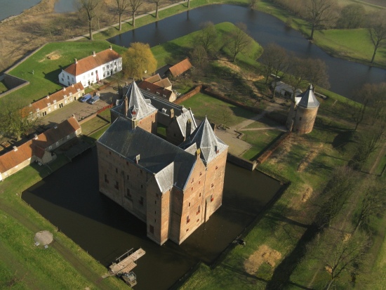 Slot Loevestein |
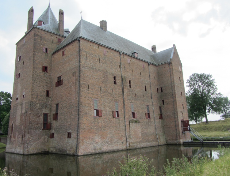
We crunched along a narrow path through a lovely stretch of meadowland, blue perennial geraniums hemming us in on either side. Crunched was the operative word since the path was strewn with mussel shells discarded by birds that had been scouring the banks of the Waal. In a matter of minutes the imposing bulk of Slot Loevestein appeared in our field of view.
Slot Loevestein (Castle Loevestein) was a medieval castle built by the knight Dirc Loef van Horne. At first, around 1361 he built a square brick building, a blockhouse. Within ten years he had turned Loevestein into a bone fide castle, "het stenen huis van Loef" (The Stone House of Loef). The castle is situated in a unique location where the river Maas and Waal converged and the provinces of Gelderland, North Brabant and South Holland meet. His choice, however, was not determined by the area's outstanding beauty, but by its strategic position. It was the ideal location to defend, and from which to levy tolls.
This impressive building caught the eye of Dirc's liege, the mighty Count of Holland. A castle as important as this was something he wanted for himself. In 1372, Loevestein did indeed pass into the hands of the count, and was no longer home to knights but to castellans appointed by the Count of Holland.
 Soldier's Barracks |
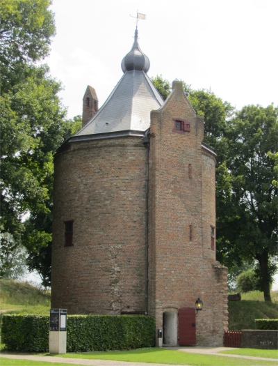 Kruittoren (Gunpowder Tower) |
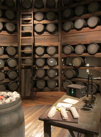 Powder Store inside the Kruittoren |
In 1672, when French troops invaded the Netherlands, Loevestein was logically incorporated into the Fortified Triangle and the Dutch Waterline. Loevestein finally lost its function as a military stronghold with the passing of a Royal Decree on 18th October 1951. Fortunately, it had remained a "monument of defence" to this day.
We entered the grounds of this historic building and found ourselves strolling along a cobbled street flanked by two rows of houses. These accommodated the soldiers stationed at Loevestein: the 14 barracks on the left dated from 1730, and the 8 barracks on the right dated from 1732. An excellent exhibition was held inside the barracks, covering 650 years of the lives, homes and work of the knights, soldiers and prisoners who lived at Loevestein, some of it quite extraordinary and some very commonplace, but they all had a story to tell. All accompanying texts to the exhibition were written in both Dutch and English - a huge bonus.
Sadly, the Commander's Residence and Scottish Room were closed to the public today, which was a pity since they were rather grand looking, whitewashed buildings. Opposite them stood the arsenal, a characteristic fortress building that dated from 1781, and was originally used as a munitions depot. The building's beautiful, high ceiling and historical character made it ideally suited for receptions, meetings, dinners and other small gatherings. Were we three a small gathering? I think not.
 Loevestein Castle |
Not far behind the Kruittoren lay a bombproof shelter. When Loevestein Castle was one of the main strongholds on the Dutch Waterline, the line had to be modernised frequently in order for it to withstand new weapons and new methods of attack. This bunker, a concrete bombproof shelter for people and materials, was built in 1883 and was the final addition to the fortress. It was covered with sand and clay to stifle bullets and grenades, but the introduction of the high-explosive shell meant that this "modernisation" became outdated almost immediately. A recording played out in the bunker told the stories of soldiers who used to live here, and how they often got bored and devised all sorts of activities to pass the time.
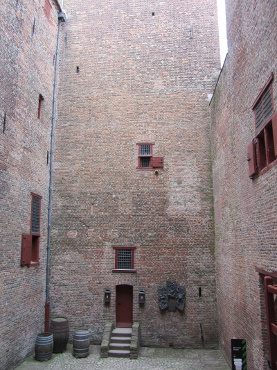
We entered the castle and engaged in a self-guided tour around the cellar, turned into a bombproof shelter in the mid-19th century, the Riddertoren (Knight's Tower), and the various rooms that would have served different functionalities depending on whether the castle was in its aristocratic, military or prison phase. It was a little gem - totally absorbing taking us centuries back in time.
One floor that deserves a mention was the first floor where "De Erfenis" (the legacy) was staged, an exhibition about Hugo Grotius and the Dutch Revolt. In one room that was Hugo's prison from June 1619 to 22nd March 1621, an animated film told the story of Hugo de Groot's life.
 Yard Inside the Castle, Almost a Prison Itself |
Now Hugo Grotius read a lot in prison. Many books were brought and collected in a large book chest, which was thoroughly inspected by the guards on every delivery. Only books were allowed in the chest, but since the chest never contained anything other than books, the guards started to check it less often. It was time for Hugo's wife, Maria van Reigersberg, who also lived in the castle, and servant girl Elsje to devise a plan. On 22nd March 1621, Hugo Grotius escaped form Loevestein in the chest. At the Daetselaar Family's house in nearby Gorinchem, he disguised himself as a bricklayer and fled to Paris. Backed by the king of France, Hugo sent a request to the States of Holland asking for his wife and children to be sent to France. This request was granted on the condition that Hugo Grotius would never return to the Netherlands. In 1634, Hugo Grotius was appointed ambassador of the Queen of Sweden to France. In 1645, however, he was shipwrecked on returning from Sweden. He did not survive the catastrophe and died in Rostock, Germany. Hugo was buried in the Great Church at Delft. It was said that in this room Hugo de Groot's spirit still lingered.
We slowly retraced our steps. At Woudrichem, while we waited for the ferry to take us back to Gorinchem, two giggly girls in their early teens clambered up on top of the pilings where the ferry would pull in. They procrastinated for some time over should they jump or not. Several old dears were perched on a bench waiting for the ferry, and they decided to egg the girls on. Perhaps they had done something similar when they were girls, I'll never know, but their ploy worked, and amid screams the two plummeted into the murky, Brown Windsor soup. Rather them than me.
Back in Dordrecht, we rounded off the informative, cultural day with a stroll around the Nieuwe Haven, stopping off for a pleasant meal near the Engelenburgerbrug.