A few hours later it was pelting down in Dordrecht too. Rex and I watched in astonishment as an old man on a barge was out in the downpour, hosing down his large boat and scrubbing it at the same time. The Dutch are obsessed with cleaning. Anticipating being on the move the next day, and all the shops being shut on Sunday, I nipped smartly along to the supermarket while Rex topped up the water.
We decided to get a water bus to Rotterdam today. Walking up to the Merwekade terminal, we passed by a repair garage, with cars up on ramps being clunked and wrenched by mechanics in ultra-clean overalls, the whole scene being reflected in the gleaming, spotless floor. Now it was time for Meryl to stare aghast.
Our water bus ferried us up the Noord through much industrial land. Indeed this waterway seemed to be an M4 of water. At Kinderdijk, the Noord converged with the Lek, it became the Nieuwe Maas. Just behind the shipyards of Kinderdijk, hidden from view, a UNESCO World Heritage park lay with 19 windmills dating from 18th century, plus a museum and working mill. Now we were on the Nieuwe Maas, huge docking complexes lined the banks, and large shipbuilding hangers squatted. Gigantic dredgers and salvage boats littered the quaysides, and the river was festooned with commercial traffic.
The Rotterdam skyline as we approached resembled London's Docklands. Soon we were gliding under the Erasmusbrug, a cable-stayed bridge across the Nieuwe Maas, linking the northern and southern regions of Rotterdam. The iconic Erasmus Bridge was designed by Ben van Berkel and completed in 1996. The 802m bridge had a 139m asymmetrical pylon, earning the bridge its nickname "The Swan". The southern span of the bridge had an 89m bascule bridge for ships that could not pass under the bridge. This was the largest and heaviest bascule bridge in West Europe and had the largest panel of its type in the world.
On alighting, we strolled up Schiedamsedijk towards the maritime museum. A very large triangular harbour was stretched out on our right hand side, which in turn contained a triangular island with quays on it. The small harbours on the island had names: Wijnhaven, Scheepmakershaven, Bierhaven, Rederijhaven and Leuvehaven, reflecting trade conducted on these wharves decades ago.
First port of call in the museum was the cafe for an essential caffeine top up. Rex of course was always keen to polish up his Dutch, and we collared the services of a waitress to pronounce a word that we had disputed the pronunciation of for some moments. I wrote the word down, "Ijmuiden", and the girl pronounced it in Dutch. The expression on Rex's face was a picture.
The museum was founded in 1874 and was the oldest maritime museum in the Netherlands. The first exhibit was mind-blowing. Set in a very large room was an equally large 3D-map of the city all the way down to Europort. Behind on large screens, maritime scenes from the port were projected. No words were spoken, mood was conveyed by light, sound and action. The old inland ports in the city now served other purposes since large ships could no longer travel up the river. The hustle and bustle of the active port was now farther and farther from the city towards Europort. The exhibition brought the feel and rhythm of the world class port back to the heart of Rotterdam. On a balcony overlooking the map and screens, a "control room" contained a bank of "time navigator" interactive screens allowing us to explore the history of the port of Rotterdam. There was enough information stored away on these computers to keep us occupied for months.
A small area of the museum described the backstage aspects of putting exhibits on show. Four themes: collecting, restoration, collection management and research, were each illustrated using items from the collection in order to give an idea of what went on behind the scenes at the museum. Part of this exhibit included the Burgerhout Panorama. The three paintings, two metres high and up to ten metres wide, were the largest maritime paintings in the Netherlands after the Mesdag Panorama. The canvases proudly depicted the history of the Burgerhout shipyard in Rotterdam, giving a unique insight into the versatility and professional skill of Rotterdam's shipbuilders. They had been kept rolled up in the depot for years, but the Burgerhout Panorama has been thoroughly restored and now had the place it deserved in the museum.
Also on the ground floor was a rather unusual exhibition, one that I would never have expected; sex and the sea. In the exhibition the British film director Peter Greenaway and the Dutch multimedia director Saskia Boddeke had produced an experience for visitors (16+) in which they put themselves in the place of the seamen. Visitors were encouraged to feel the same emotions of homesickness and sexual desire that seamen are faced with when they are at sea for months on end, and staying in unfamiliar ports. Far away from their homes, other norms and values can sometimes hold sway. Will the passing sailor allow himself to be tempted in these exotic locations? Does he have a different girl in every port? Does the lonely sailor write home every day? Or may a young hothead see the shape of a mermaid when a manatee appears? Greenaway and Boddeke had translated this into an artistic film project comprising images of maritime erotic artworks, pin-ups, mermaids, postcards, photographs and unique quotes from seamen about lust. Hmm.... perhaps I had never been at sea long enough for this to bother me.
The second floor contained two exhibitions, the first concerning itself with Dutch maritime high-technology. Flows of goods transported by water were still increasing, and ports, waterways and ships had to be changed to allow for this, demanding more and more high technology in ship, harbour and waterway construction. In addition we were having to find oil, gas and raw materials further off shore and in deeper water. This exhibition, which had been put together in cooperation with IHC Merwede, offered a look behind the scenes at the world of the dredging industry, the offshore sector and mining. It addressed such questions as what do you need if you want to deepen the Panama Canal by digging out the tough bedrock and sucking up the rubble? How can you create new land in the sea, as was done for Maasvlakte 2? What do you have to take into account if you want to lay pipelines in 2000 metres of water to a deep-sea oil field?
The other exhibition on this floor explored aspects of living on the water. The Netherlands was genuinely a country of water, and where there's water, there are people living on it. But what made people want to live on the water? And what made people who live on the water love it so much? Everyone who is used to terra firma under their feet wonders sometimes what it is like to live on a houseboat. Is there enough space? Do you get seasick? What's it like in winter? What kind of boats can you live on? How do you get your mail? I'm sure many of the folk who lived on boats at Tollesbury saltings could answer these questions, and more. This family exhibition allowed us to see what living on the water in the Netherlands was typically like, using models of various houseboats and waterborne accommodation (a pontoon houseboat, a boat conversion and a water villa). What did enthral Meryl and I was a continuous loop of projected interviews with a variety of houseboat residents, young and old, who related everything about their very different reasons - and the love they had in common - for living on the water.
On the top floor we discovered the "Sea Palaces. On holiday with a cruise ship" exhibition. Unlike Rex and Meryl, I have never been on a cruise ship, and probably never will. However, this exhibition gave the flavour of what it would have been like to stay on such an impressively tall ship, with twelve passenger decks and a tropical swimming paradise and tennis court on board. I could relax in a deckchair by the swimming pool just like a real passenger, sit at the captain's table for dinner and find out everything about cruise travel. What happens to the 10,000 suitcases that go on board, what's the trick to folding bath towels into swans, and what did the special cruise money that was used for payments on board in old days look like? The exhibition also gave Meryl a chance to indulge in one of her favourite pastimes, karaoke - sad, I know.
Also on the top floor was Professor Splash's adventure in the port, aimed at children aged from 4 to 10. Rex and I could fit into that category quite well. As we were leaving the top floor, a whole school worth of screaming, excited school children poured out. Rex was soon strutting around herding them away; he reminded me of the teacher in the Beano. We too took our leave of the place. This museum was absolutely superb, and earned its reputation as one of the world's top maritime museums.
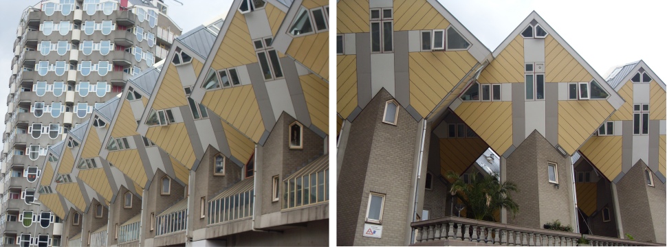 Cube Houses |
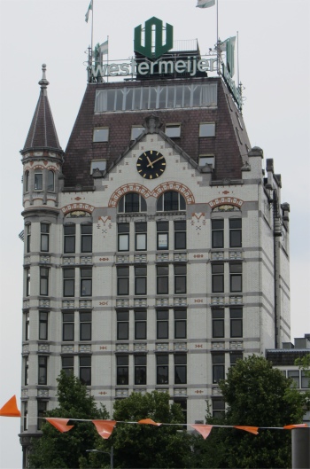 Het Witte Huis |
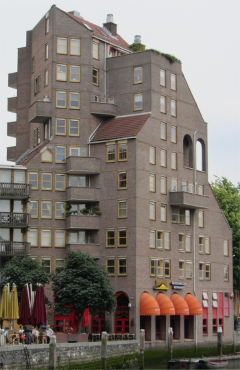 Oude Haven Houses |
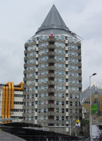 Het Potlood (The Pencil) |
The Oude Haven contained a mix of new urban cafes and restaurants. In short: an urban hangout where living, working and entertainment went hand in hand. Naturally, since it was well past noon, we decided to take time out and enjoy a light lunch in one of these cafes. Meryl and I partook in bowls of mustard soup, while Rex ordered a BLT; it would have fed an army. The idyllic setting was shattered by a terrible din. A truck had been delivering huge sacks of coping stones destined for the Gelderseplein in front of Het Witte Huis. The driver's life became a nightmare when he was craning out one of the large sacks, the sack split all over the back of his truck with a tremendous crash. He had his work cut out for the next half hour.
With our batteries recharged we walked up past the new Market Hall whose construction was almost complete. At the place where Rotterdam was founded, near the historic Laurens church, the Market Hall will be realised as a new urban typology. The Market Hall is designed as a sustainable hybrid of food, leisure, living and parking, fully integrated to celebrate and enhance the synergetic possibilities of the different functions. The building will comprise 228 apartments forming a tunnel over the market hall, with each apartment featuring a balcony on the exterior of the building and a window onto the market hall below. A secure, covered square lay beneath an arch, glazed at each end, housing 100 market stalls, shops and restaurants, and was conceived as an inversion of a typical market square and its surrounding buildings. During the day it would serve as central market hall, after hours the hall would become an enormous, covered, well lit public space. In addition 1,200 parking spaces and a supermarket were to be located underground. I for one was astonished by the ingenuity of the architecture of this city.
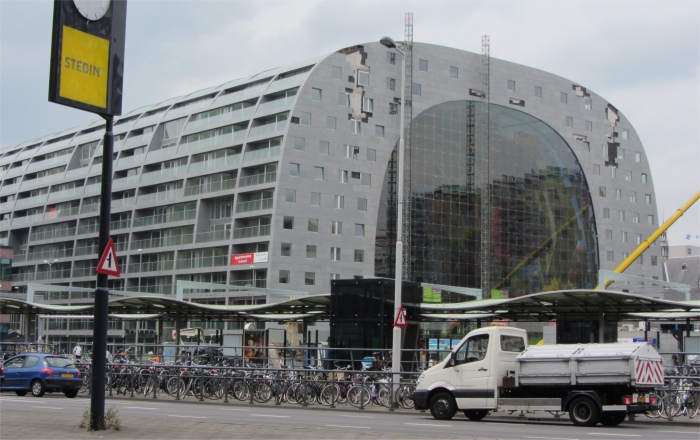 New Market Under Construction |
Like many church towers in the Netherlands, during the 17th century the tower however was sagging, and proved to be dangerous for the rest of the church during a storm in 1650. In the next five years work was carried out to set the tower straight again and to strengthen the foundation underneath it. For almost three centuries little more changed on the exterior of the church. On the 14th May 1940 German planes bombed the centre of Rotterdam. After the debris was removed, what had been a crowded city was turned into a vast empty space, with only a few ruins left standing. One of these ruins was that of the old Laurenskerk. After the war, functionalist architects rebuilt the centre. Despite their objections the old church was saved from demolition, as it was the only church in the bombed part of the centre, and was completely restored from 1952 until 1968. Today the church was all that was left of medieval Rotterdam. Modern skyscrapers now dominated the city's skyline.
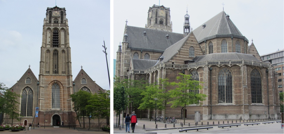 Laurenskerk |
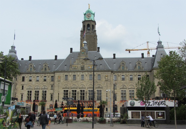 Stadhuis |
We crossed the stretch of water known as the Delftsevaart and made our way to the Stadhuis (city hall). This Town Hall on the Rotterdam Coolsingel was built between 1914 and 1920 and designed by Prof. Henri Evers. It is one of the few buildings in the centre of Rotterdam that survived the German bombings in 1940.
We now needed to cross the Coolsingel, one of the best known streets in Rotterdam, that connected Hofplein with Blaak. This central artery of downtown was always busy, not only with traffic, but the street was brimming with upmarket stores existing cheek by jowl with commerce, cafes, bars and restaurants. Coolsingel was the meeting point for locals at a major festivals or events such as the marathon. We needed to have our wits about us crossing this hectic thoroughfare. Cyclists attacked from all directions, none of them seeming to have bells on their machines. Cars, motorbikes, buses, trams and trucks hurtled by. The street was heaving with people, did nobody ever work here?
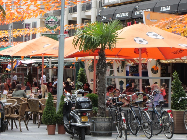 Patriotic Pedestrianised Area |
It was time to head back towards the ferry terminal, sadly passing an art gallery that we didn't have time to visit. Soon we were sat on a bench by the Nieuwe Maas, surrounded by the new architectural developments in the modern-day "Manhattan on the Maas", patiently waiting for our ferry to arrive. We had crammed a lot in during our 5.5 hour walk around this city.
It gave us time to reflect on where this modern city had sprung from. Already around 900 AD there were settlements in the area around the Rotte estuary, the Rotte River being another tributary in the Rhine River delta. The nobles of the area had each made their own protective walls against the frequent floods. Count Floris V (1256-96) ordered the Lords to connect their individual dykes in order to construct one single sea wall against the floods. This sea wall cut off the Rotte from the River Maas. This part of the wall was called Middendam (Middle Dam; now Hoogstraat), and it was around this dam that Rotterdam developed as a small fishing settlement. In the decades after that the settlers around the Middendam gained privileges from the Counts of Holland. In 1340 Count Willem IV granted a city charter to the areas East and West of the River Rotte. The city was also allowed to dig a canal to the River Schie (Rotterdamse Schie, another tributary of the Nieuwe Maas) to establish a connection with the Dutch hinterland (Delft, Leiden, Haarlem), and it became the major port of the province. In 1358 Rotterdam got permission to build city walls.
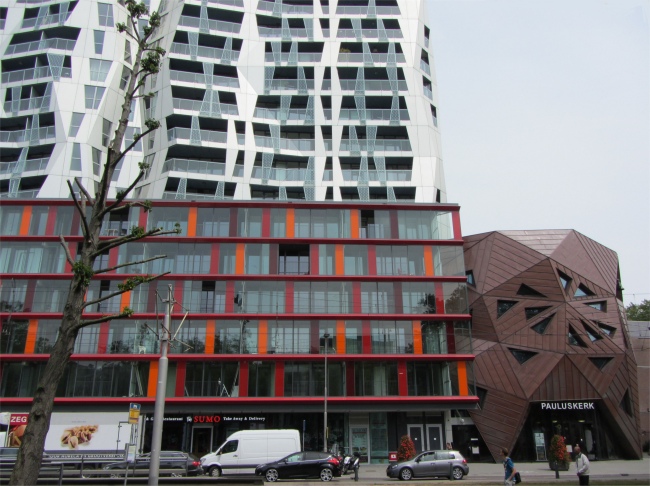 More Creative Architecture |
Economically the next era was one of growth and prosperity. Trade and shipping flourished. Especially the trade with England, France, America and even Spain increased. The location was good, but also the political circumstances favoured Rotterdam. Delft kept its satellite port of Delfshaven in check because of short term interests, Schiedam was too thrifty to invest in a port and Amsterdam and Antwerp - both still on the Spanish side - were blocked by the fleet of the rebellious provinces. When Amsterdam chose the side of the rebellion a lot of trade went back there. The establishment of the Admiralty in Rotterdam (1586), a Chamber of the Dutch East Indies Company (1604) and the West Indies Company (1621), and of the Merchant Adventurers (1635) were proof of growing trade. In the 17th century, when the discovery of the sea route to the Indies gave an enormous impetus to Dutch commerce and shipping, Rotterdam expanded its harbours and accommodations along the Maas. Before the end of the century it was, after Amsterdam, the second merchant city of the country.
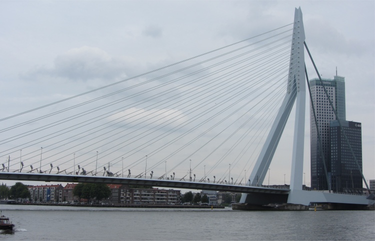 Erasmusbrug |
On 14th May 1940, during the Second World War, almost the inner city and the 17th century port were completely destroyed in a massive bombardment. Without any hesitation, the reconstruction programme was launched within two weeks of the war's end. Rotterdam made a radical break with the past and blazed a new trail, redefining the face of the city. Light, air, space and functional architecture were the watchwords. The original street plan was abandoned and the city centre was being connected by wide avenues. In 1954, the Lijnbaan Shopping Centre became the prototype for similar centres in Europe and America that allowed only pedestrian traffic. Rotterdam literally rose from its ashes and owed its contemporary image to the drive for innovation.
Back at base, despite evidence of recent downpours, a woman was watering her plants, or was she cleaning them?
We went off to the same restaurant as the previous night; the food was good, so an obvious choice. Nobody was sitting outside, all the seats being wet from the rains, so we had to wait a short while at the bar for a table to become free inside. As I ordered drinks, I detected an English voice, and recognised a chap at the bar. We had seen him earlier in the week at the check-out of a supermarket. At the time, Rex had made the comment, "I don't know if these bags will handle the weight of the food and beer." The chap had interjected in English as he picked up his bags, "Drink the beer as you go along, the bags will then become lighter." He immediately left with a grin on his face. I could swear this was the same chap at the bar, and I struck up a conversation with him. He was indeed the same fellow and it turned out to be a small world, he originated from my home town in Cumbria. When work dried up in his home territory 7 years ago, he came across to Dordrecht and never left. Now he had a family here. When asked if he liked living over here, he was indifferent. However, he bemoaned the fact that he paid 40% tax, commenting that 70% of the nation received some form of benefit. We never got a chance to bottom that one out, our table had become available. Mind you when I think about it, if one takes child benefits etc. into account in Britain, what percentage of the British are on benefits?
We enjoyed a good meal. Rex and Meryl were in lu-lu mode, exchanging endearments - don't ask. Tonight we settled down early, we had a long trip ahead of us in the morning.